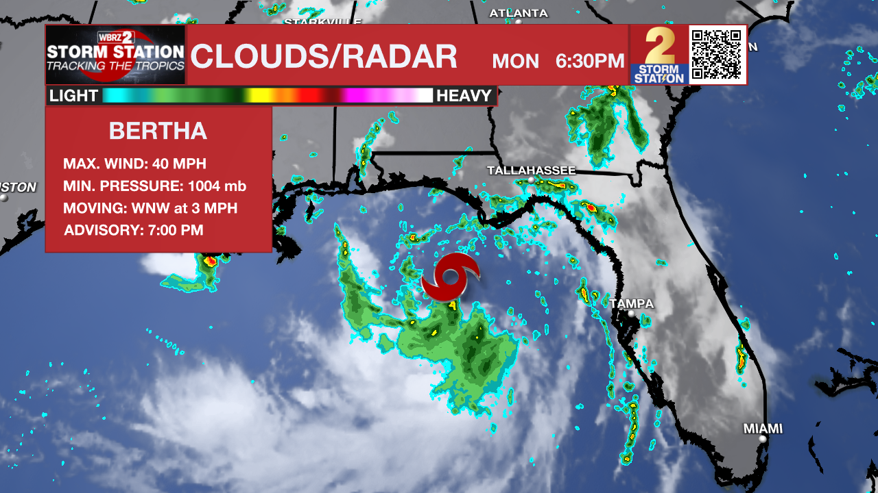
UPDATE: Now with maximum sustained winds at 40 mph, Tropical Storm Bertha has developed in the northeast Gulf. While a westward track toward Louisiana is the likely scenario, overall impacts to the Capital Area will be low. Skip ahead to The Tropics section below for a full breakdown.
Meanwhile, intense summer heat will persist into Tuesday, with afternoon highs potentially inching toward the upper 90s. A Heat Advisory will go into effect again, as the heat index could approach 110° at times. Stay hydrated and try to take breaks if spending time outdoors for multiple days.
Tonight & Tomorrow: The few afternoon storms that popped will fade into the evening hours, leaving behind mostly clear skies with lows dropping into the mid-70s by morning. Expect another hot day on Tuesday. Sunshine will push temperatures to 90° by lunchtime before eventually peaking around 97° in the afternoon. There will be another Heat Advisory in effect from Noon until 7 p.m. Tuesday as the heat index could exceed 108° for an hour or two. Let this advisory serve as a reminder to stay hydrated, pace outdoor activities, and understand the warning signs of heat illness. Listen to your body and head indoors to air conditioning immediately if you start feeling unwell.
Late in the day, isolated thunderstorms may bring a few bursts of relief from the high heat. These will likely be embedded within an outer rainband of Tropical Storm Bertha, which will sit to the east in the northeast Gulf. Check The Tropics section below for a full breakdown of the system spinning in the Gulf.
The Tropics: Bertha became the second named storm of the 2026 Atlantic hurricane season after NOAA Hurricane Hunter aircraft found evidence of tropical-storm-force winds on Monday evening. The storm won’t have much time to strengthen in the coming days, likely limiting the peak intensity to tropical storm strength. The storm is moving slowly as of late, but Bertha will eventually get a kick to the west by midweek, likely brushing up against the Louisiana coast. Tropical rainbands may begin moving through as early as Tuesday afternoon and continue periodically through Thursday.

The latest guidance suggests that the storm will track south of I-10, toward the coast and possibly offshore. The Storm Station expects impacts for inland locations to be relatively minimal as far as tropical systems go. This is due to a variety of reasons, including a moderate amount of wind shear. Not only will this prevent significant strengthening, but it will also create a lopsided storm. This will shove the majority of the heavy rain and wind toward the coast and offshore. Coastal areas could experience minor storm surge, coastal flooding, gusty winds, and heavy tropical downpours. Keep an eye out for potential tropical alerts later in time.
While the overall impact of this system appears low, a nearby tropical storm always demands attention. Check back in with the Storm Station each day as the forecast gets narrowed down.

Up Next: Periodic tropical downpours will continue through Thursday, especially south of I-10. Outside of these showers, intense heat and humidity will dominate. As the tropical system pulls away late in the week and into the weekend, the summer heat will continue to bake the Capital Area.
Get the latest 7-day forecast and real-time weather updates HERE.
Watch live news HERE.
— The Storm Station Meteorologists
The Storm Station is here for you, on every platform. Your weather updates can be found on News 2, wbrz.com, and the WBRZ WX App on your Apple or Android device. Follow WBRZ Weather on Facebook and X for even more weather updates while you are on the go.