

Latest Weather Blog
Friday PM Forecast: what to wear for Mardi Gras parades in the Capital Area this weekend
If you’ve been waiting for a reason to get outside, look to the Baton Rouge weather forecast this weekend. Expect clear skies and temperatures that feel more like April than early February. Aside from a very brief "speed bump" on Saturday, the Storm Station 7-Day Forecast will feature a warming trend.
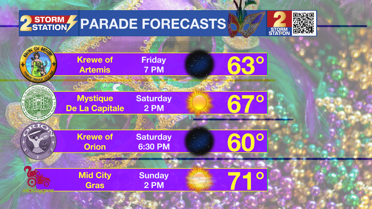
Mardi Gras 2026 parades will be in great shape this weekend. Conditions will certainly be dry, and winds will be light. Friday and Saturday night will be falling out of the 60s and into the 50s—cool enough that you’ll want to have a layer to add out at the Krew of Artemis or Krewe of Orion parades. Saturday afternoon now looks a few degrees cooler than it did earlier in the week, and so long sleeves might be more comfortable than short sleeves for Le Krewe Mystique de la Capitale. Sunday afternoon will be about 5 degrees warmer for Mid City Gras.
Weekend: mild, dry
Monday: 70s, generally quiet
Trending News
Tuesday & Wednesday: spotty showers, still warm
Tonight & Tomorrow: A cool night is ahead with low settling in the mid 40s—very close to average for the time of year. Skies will remain clear. Saturday will be clear with lots of sunshine. A weak cold front will pass through, but shouldn’t be noticeable in any way. While highs will slide into the upper 60s, a breeze could make it feel cool at times, and so will any shady areas. A jacket or long sleeves may come in handy at times.
Up Next: Saturday night will be the chilliest point of the Storm Station 7-Day Forecast, with lows dipping into the upper 30s, so make sure the pets have a warm place to sleep! By Sunday, the warming trend will take full effect as highs bounce into the low 70s. By Monday and Tuesday, afternoon highs will peak in the mid-70s. These temperatures are about 10 degrees above average for the time of year.

A quick-moving disturbance might spread a few showers across the region later Tuesday into Wednesday. Any rain that does fall will be light and should not have a major impact on outdoor activities or commutes. Toward the end of next week, a more substantial rain chance may materialize, but it is too early for details on that one.
Get the latest 7-day forecast and real-time weather updates HERE.
Watch live news HERE.
– Josh
The Storm Station is here for you, on every platform. Your weather updates can be found on News 2, wbrz.com, and the WBRZ WX App on your Apple or Android device. Follow WBRZ Weather on Facebook and X for even more weather updates while you are on the go.
More News
