

Latest Weather Blog
LATEST: Dangerous wind chills Monday morning
Extreme cold grips the region today as Arctic air settles in. While winter precipitation is long gone, dangerous temperatures and wind chills remain a serious concern through Tuesday morning.
An EXTREME COLD WARNING will remain in effect until noon Tuesday for all of southeast Louisiana and southwest Mississippi. Dangerously cold wind chills as low as 4°F are expected. Frostbite and hypothermia will occur if unprotected skin is exposed to these temperatures. An extended period of freezing temperatures could cause ruptured water pipes.
HOW WIND CHILL WORKS - INSIDE THE WEATHER WITH WBRZ CHIEF METEOROLOGIST, DR. JOSH EACHUS
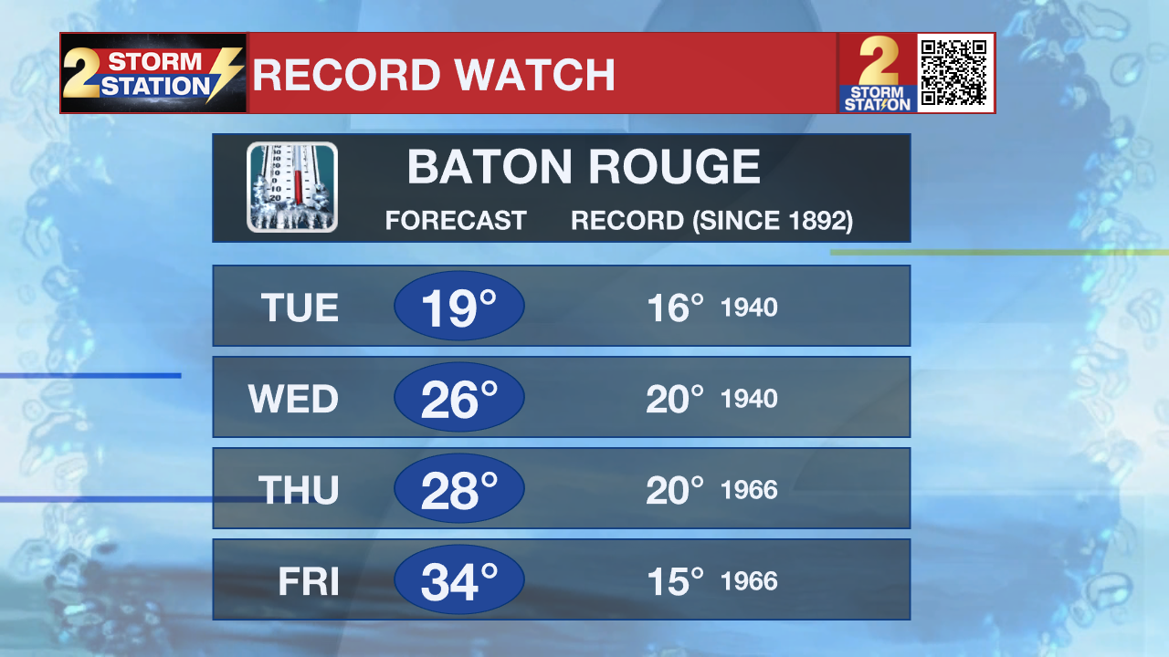
Monday starts bitterly cold across the entire region following Sunday’s system. Morning wind chills range from the single digits to the teens, making it dangerous to be outdoors for an extended period of time. Sunshine returns during the day, but temperatures struggle to recover, topping out only in the 30s to near 40 — more than 20 degrees below normal. Northwest winds remain gusty, keeping the cold locked in place. Tonight will be frigid once again, with lows falling into the teens and 20s as the Arctic air mass remains firmly in control.
Trending News
Dress in layers including a hat, face mask, and gloves if you must go outside. To prevent water pipes from freezing; wrap or drain or allow them to drip slowly. Keep pets indoors as much as possible. Make sure outdoor animals have a warm, dry shelter, food, and unfrozen water. Make frequent checks on older family, friends, and neighbors. Ensure portable heaters are used correctly. Do not use generators or grills inside. If you do not have heat in your home or lack shelter, you can call 211 for assistance locating appropriate shelter from the cold. Use caution while traveling outside. Wear appropriate clothing, a hat, and gloves.

Arctic Blast: The extreme cold continues through Tuesday morning, with lows hovering around 20. Gradual moderation begins Tuesday afternoon, though temperatures remain well below normal. The midweek will remain cold, with highs only reaching the upper 40s to lower 50s through Thursday, thanks to a reinforcing cold front. Confidence lowers heading into next weekend, but another weak system could bring light precipitation late Friday into Saturday.
-----------------------------------------------------------
Click the icons below for resources:


Get the latest 7-day forecast and real-time weather updates HERE.
Watch live news HERE.
The Storm Station is here for you, on every platform. Your weather updates can be found on News 2, wbrz.com, and the WBRZ WX App on your Apple or Android device. Follow WBRZ Weather on Facebook and X for even more weather updates while you are on the go.
More News
