

Latest Weather Blog
Saturday PM Forecast: Another cooler morning in store, Humberto becomes a category five
We will once again get close to light jacket territory Sunday morning, so get outside early to enjoy the refreshing feel. In the tropics, Hurricane Humberto has rapidly strengthened into a category five hurricane!
Tonight & Tomorrow: Drier air is still in place, which will allow lows to drop near 63 degrees overnight. Temperatures will rapidly rise after sunrise, and eventually top out near 89 degrees. Yes that is very warm, but humidity will stay on the lower side. Skies will be mostly sunny with rain chances near zero.
Up Next: For the most part, all of next week will feature pretty quiet weather conditions. Temperatures and humidity will start to work their way up through the middle of the week. It won't be a major change, but it will start to feel a touch muggy. Rain chances will near zero through Wednesday, but after that point, a few showers will be possible day to day. This will be driven by a trough of low pressure. This same trough might also bring temperatures down a few degrees.
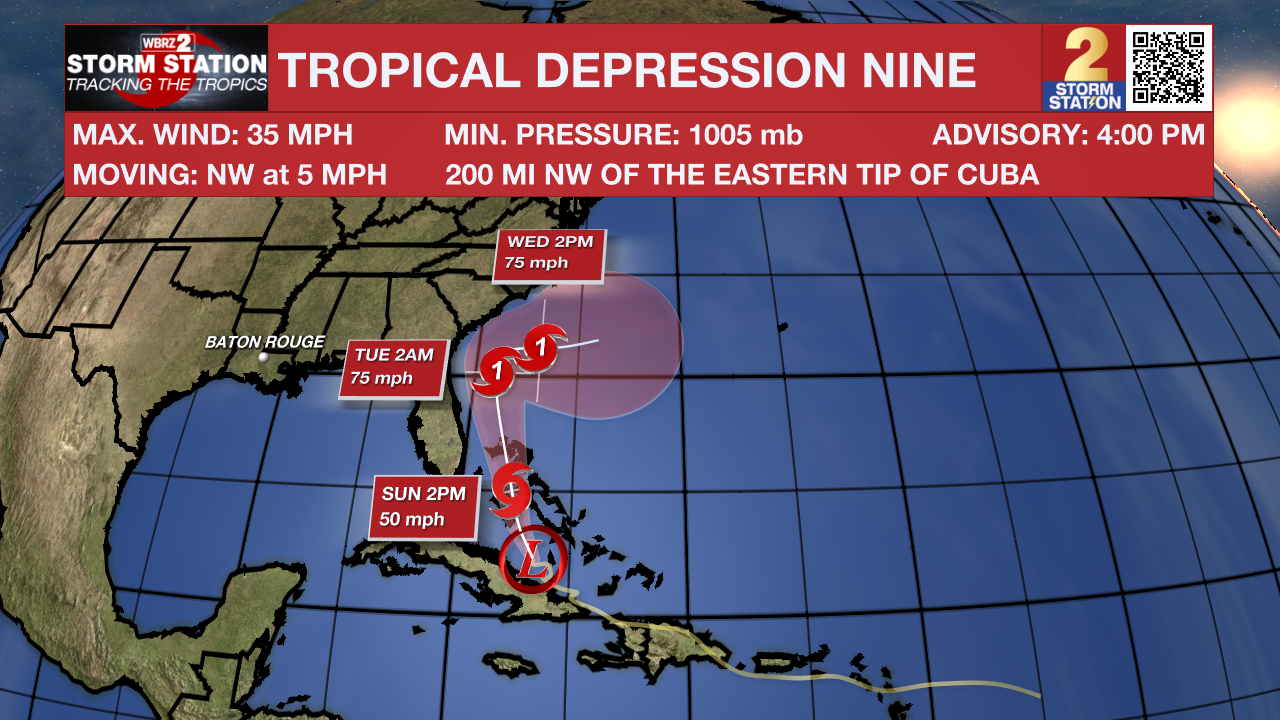
The Tropics: The tropical depression hasn’t changed much since this morning. Some storms have flared up near the broad center, but data from both satellites and aircraft suggest it hasn’t strengthened yet, with winds holding near 35 mph. The center is a little farther south and west than earlier estimates, and the system is drifting northwest. Over the next couple of days, it should track over the central and northwestern Bahamas and then move toward the southeast U.S. coast by Tuesday. Conditions are generally favorable for it to strengthen, and it could become a hurricane early next week. Forecast confidence decreases after that, as Hurricane Humberto to the east may cause the storm to slow and stall near the U.S. coast. While the chances of a direct landfall are lower than before, heavy rain, storm surge, and strong winds remain possible along the southeast coast, even if the center stays offshore. By late next week, the system may either turn eastward away from land or linger offshore, with a chance of transitioning into a non-tropical system if it interacts with a cold front.
Trending News
Humberto has rapidly strengthened into a Category 5 hurricane, with winds now estimated at 160 mph. Satellite imagery shows a nearly perfect ring of very cold cloud tops surrounding a clear, well-defined eye. While earlier estimates suggested slightly lower intensity, the storm has continued to intensify, making it the second Category 5 of the 2025 season. Some further strengthening is possible in the short term, but natural eyewall replacement cycles could cause the winds to fluctuate over the next day or two. Gradual weakening is likely to begin by Monday, especially as the storm interacts with a weather system moving in from the U.S., which will also help shift Humberto toward becoming a non-tropical system. This change will lower its top winds but broaden the area of strong winds. The track forecast is mostly unchanged, though Humberto has picked up a little speed and shifted slightly west. Over the next few days, it should curve around the subtropical high and then race northeastward. There is less certainty now about how quickly it will make that turn, but the overall forecast remains largely consistent with previous outlooks.
Get the latest 7-day forecast and real-time weather updates HERE.
Watch live news HERE.
– Balin
The Storm Station is here for you, on every platform. Your weather updates can be found on News 2, wbrz.com, and the WBRZ WX App on your Apple or Android device. Follow WBRZ Weather on Facebook and X for even more weather updates while you are on the go.
More News
