

Latest Weather Blog
Storms pushing through the Capital Area, Tornado Watch remains in effect
UPDATE - 6 a.m. Sunday: Showers and thunderstorms continue to roll through the Capital Region. Several tornado warnings have occurred just outside of the Capital Region, and most of the severe weather will push east, where a new Tornado Watch is in effect until noon and includes southeast Louisiana and coastal Mississippi. All watches have been dropped for the WBRZ viewing area.

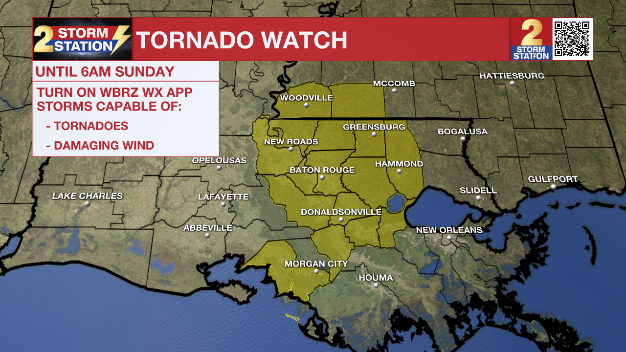
The National Weather Service has issued a ***TORNADO WATCH*** for East Baton Rouge, West Baton Rouge, Ascension, Assumption, Iberville, East Feliciana, Livingston, Pointe Coupee, St. Helena, St. James, St. Mary, and West Feliciana Parishes, as well as Amite and Wilkinson Counties until 6 a.m. Sunday.
Trending News
A TORNADO WATCH means conditions are favorable for tornadoes and/or damaging winds in and around the watch area. Be on the lookout for threatening weather conditions and listen for later statements and possible warnings. If a tornado warning is issued, seek shelter in a low-level, interior room of a sturdy building. Take pets (on a leash) with you, have on hard-soled shoes, monitor storm coverage on a wireless device, and cover your head in the event of wind or tornado impact. For more on tornado safety, CLICK HERE.
A widespread line of storms will march into the Capital Area after midnight, most likely in the 2-5 a.m. timeframe. Beforehand, isolated activity will develop ahead of the main line.
Any of the late-night storms could end up on the strong to severe side, with damaging winds and isolated, brief tornadoes being the primary concerns. While the vast majority will not experience severe weather, a few unlucky spots might. So be sure to have a way to get weather alerts before going to bed, in case a Severe Thunderstorm or Tornado Warning is issued in your neighborhood. All told, an additional 1-3” of rain is expected, but a few point locations may experience higher totals. This should be a beneficial soak for most locations, as long as it does not fall too fast.
Sunday: While overnight showers and storms may linger into the early morning hours, rain will move out quickly after sunrise. Nothing more than a spotty thunderstorm is expected during the afternoon. Skies will show some signs of clearing as well, helping to push highs closer to 80°.
Up Next: Rain will be more difficult to find early next week. Humidity will take a step back to more comfortable levels, with highs near 80° and lows hovering on either side of 60°, depending on the day. A strong cold front is set to move through on Tuesday night, with only a slight chance of a passing overnight shower. But the bigger story will be the drop in temperatures behind the front. Daytime highs will drop into the 60s on Wednesday and Thursday, with lows reaching the low to mid-40s by the end of the week. Halloween looks to be on the cooler side this year, with temperatures falling through the 60s and into the 50s during trick-or-treating.
The Tropics: Hurricane Melissa rapidly intensified into a major hurricane on Saturday evening while beginning a westward drift just south of Jamaica. Intensification will continue, and Melissa might be a Category 5 storm by Monday. Early next week, the storm will turn north toward Jamaica, where a landfall looks increasingly likely. A multi-day period of damaging winds, heavy rainfall, and storm surge is expected, leading to catastrophic and life-threatening flash flooding and numerous landslides. After impacting Jamaica, Melissa is forecast to track toward eastern Cuba, the southeastern Bahamas, and the Turks and Caicos Islands.

Get the latest 7-day forecast and real-time weather updates HERE.
Watch live news HERE.
— Meteorologist Malcolm Byron
The Storm Station is here for you, on every platform. Your weather updates can be found on News 2, wbrz.com, and the WBRZ WX App on your Apple or Android device. Follow WBRZ Weather on Facebook and X for even more weather updates while you are on the go.
More News
