

Latest Weather Blog
Sunday AM Forecast: Early season freeze expected Tuesday
Cooler air is pouring in behind a strong front that’s sweeping through south Louisiana and Mississippi. After a warm start to the weekend, a big change is underway with gusty winds and much colder temperatures ahead.
Today and Tonight:
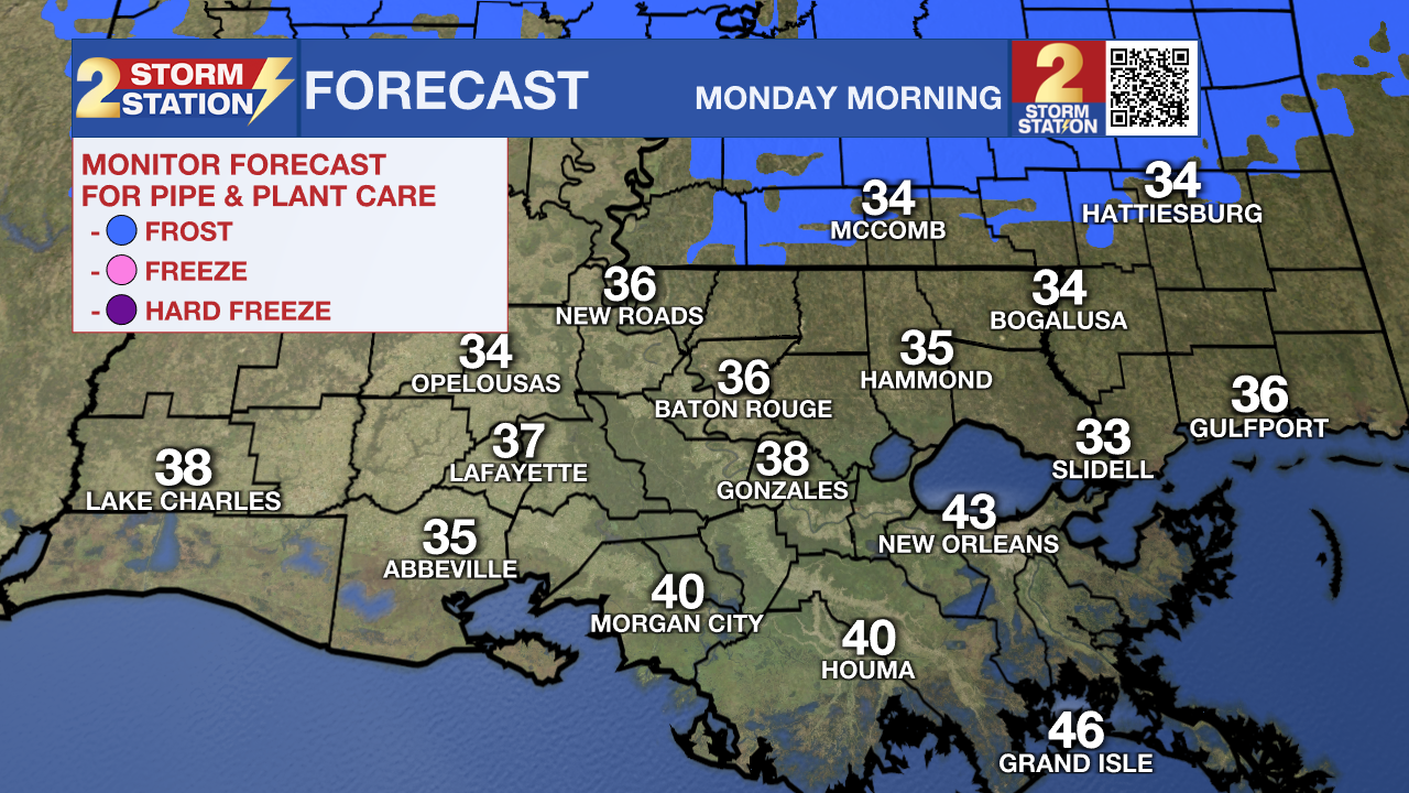
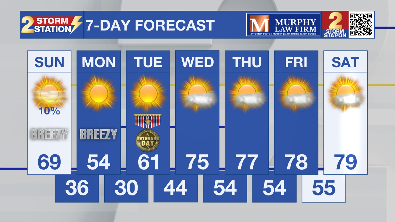
Scattered showers are moving out as our front clears the region. Behind the front, skies will gradually clear and winds will turn strong out of the northwest, with gusts up to 25mph at times this afternoon. Temperatures will top out in the upper 60s to near 70 early in the day, then tumble quickly tonight. By Monday morning, lows will dip into the upper 30s to near 40, with a stiff breeze still making it feel colder.
Dry air combined with gusty northwest winds up to 20–25 mph will create an elevated fire danger on Monday. Avoid outdoor burning if possible, and follow any local burn restrictions that may be issued.
Winter Blast:
Trending News
The coldest air of the season so far arrives early Tuesday. Clear skies, calm winds, and dry Arctic air will create perfect conditions for temperatures to drop below freezing north of I-10/12, including parts of the Baton Rouge area and southwest Mississippi.
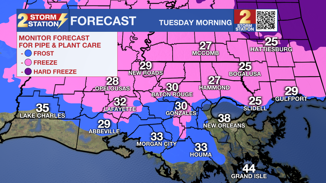
Generally, a light freeze is expected in these locations, but some of the colder river basins may briefly dip into the mid-20s. The Metro is expecting lows near 30. Even areas closer to the coast will feel the chill with lows in the mid-30s. Now is the time to cover pipes, bring pets inside, and protect plants before the bitter cold settles in.
By Tuesday afternoon, sunshine helps temperatures rebound into the mid to upper 50s, but the morning freeze could be enough to damage sensitive vegetation. Dry continental air combined with gusty northwest winds up to 20–25 mph will create an elevated fire danger on Monday. Avoid outdoor burning if possible, and follow any local burn restrictions that may be issued.
Up Next:
A warming trend takes shape mid-to-late week. Highs return to the 70s by Thursday and Friday under mostly sunny skies. Another weak front may approach next weekend.
Tropics:
The Atlantic Basin remains quiet as we move deeper into November. The National Hurricane Center reports no tropical cyclone formation expected over the next seven days. The 2025 hurricane season officially ends November 30, and conditions remain unfavorable for development.
Get the latest 7-day forecast and real-time weather updates HERE.
Watch live news HERE.
– Dave
The Storm Station is here for you, on every platform. Your weather updates can be found on News 2, wbrz.com, and the WBRZ WX App on your Apple or Android device. Follow WBRZ Weather on Facebook and X for even more weather updates while you are on the go.
More News
