

Latest Weather Blog
Sunday PM Forecast: pleasant weather to start week, but humidity will return
A big, dominant dome of high pressure anchored over the eastern U.S. is continuously funneling dry, comfortable air into our region. This means sunshine, blue skies, and low humidity for the start of the work week.
Tonight & Tomorrow: If you’re heading out or waking up early, be prepared for a brisk start, especially away from the immediate city and the lakes. Lows will likely dip into the upper 50s in the Baton Rouge Area, and may even reach the low 50s in some of the more rural, low-lying drainage basins north and east of the city. A light jacket may come in handy a few hours either side of dawn. Highs will surge right back into the mid 80s on Monday afternoon with almost full sunshine.
Up Next: Afternoon highs will steadily climb through midweek, reaching close to 90 degrees by Wednesday. For October, that’s about 5 to 7 degrees above our average. The good news is that while the afternoons are warm, the dry air will keep things comfortable enough for outdoor activities, though you’ll want to stay hydrated—that dry air can pull moisture out of you pretty quickly.
The biggest shift will come toward the end of the week, and that will be a change in how the air feels. Our winds will start to shift from the north to the east and eventually the southeast. This southerly flow will slowly but surely drag up the moisture levels. It won’t be immediately humid like a typical summer day, as the afternoon heat will still mix out some moisture, but that crisp feeling you may enjoy will begin to fade by Thursday and Friday.
By the time we hit the weekend, you’ll notice the air is feeling heavier. With that, our next rain chances start to enter the forecast, ticking up to 10% on Friday, 20% on Saturday, and 30% by Sunday as the next cold front approaches. While confidence is low right now, that system could not only return some helpful rain but possibly another cooldown to push temperatures closer to seasonal averages.
Trending News
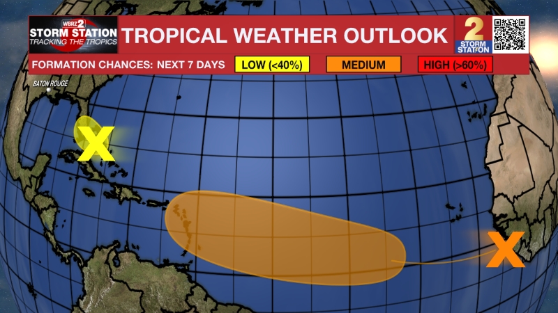
The Tropics: A large area of disorganized showers and thunderstorms is currently active over the central tropical Atlantic, generated by an area of low pressure located well to the west-southwest of the Cabo Verde Islands. Conditions appear favorable for this system to develop, and there is a medium chance that a tropical depression could form over the next seven days as the system moves rapidly toward the west-northwest or northwest at a speed of 15 to 20 mph.
Get the latest 7-day forecast and real-time weather updates HERE.
Watch live news HERE.
– Josh
The Storm Station is here for you, on every platform. Your weather updates can be found on News 2, wbrz.com, and the WBRZ WX App on your Apple or Android device. Follow WBRZ Weather on Facebook and X for even more weather updates while you are on the go.
More News
