

Latest Weather Blog
Sunday PM Forecast: Week starts dreary, turns steamy, then ends cooler
Dreary conditions and passing showers will hang on through the night and into at least part of Monday. As the rain tapers off, a more summer-like feel returns. Then, a cold front will move in to usher in a much more pleasant stretch of weather.
Tonight & Tomorrow: Expect a mostly cloudy night with lows dropping into the low 70s. Though much of the evening looks dry, a few nuisance showers will linger as a storm system hangs out by the coast. Overnight, a southeast wind in the lower atmosphere will turn more southerly. This warm and moist flow coming directly from the Gulf will fuel another round of rain. Scattered showers and the occasional rumble of thunder should develop sometime after midnight and continue through sunrise.
At least for the first few hours of daylight, off-and-on showers will be a possibility. Keep this in mind for the morning commute, as it doesn’t take much rain to cause some slowdowns. Rain will start thinning out in coverage by afternoon, but still, isolated storms will be out there. A little more than half will experience rain on Monday once or twice. As rain becomes less common during the afternoon, sunshine will begin poking through. That will be enough to nudge highs into the upper 80s.
Up Next: Tuesday and Wednesday will feel more like summer, with humid mornings in the low 70s, afternoons warming near 90°, and a few pop-up storms bubbling up from time to time. But an arriving cold front will change the narrative and send summer packing for the second half of the week. That front will slide through the region in the Wednesday/Thursday timeframe. A change will be felt afterward, with highs returning to the 80s and lows settling in the low to mid-60s. The more pleasant feel will come with plenty of sunshine and remain through the weekend.
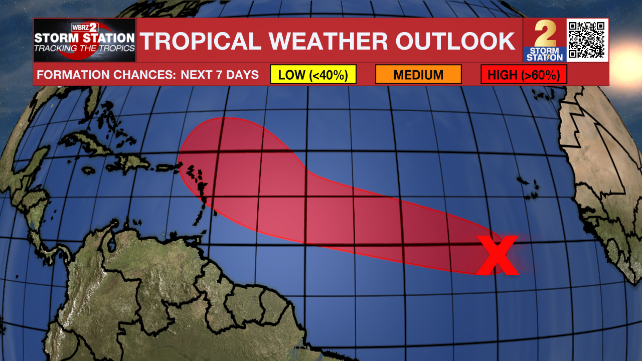
The Tropics: A broad area of low pressure associated with a tropical wave located several hundred miles southwest of the Cabo Verde Islands remains disorganized. Additional development of this system is likely this week, and a tropical depression is likely to form as it moves across the central tropical Atlantic. Portions of the Leeward Islands should monitor the progress of this disturbance as it approaches by late week.
Trending News
Get the latest 7-day forecast and real-time weather updates HERE.
Watch live news HERE.
— Meteorologist Malcolm Byron
The Storm Station is here for you, on every platform. Your weather updates can be found on News 2, wbrz.com, and the WBRZ WX App on your Apple or Android device. Follow WBRZ Weather on Facebook and X for even more weather updates while you are on the go.
More News
