

Latest Weather Blog
Thursday PM Forecast: Storms eyeing the weekend, one day standing out as wetter
A storm system will develop offshore over the weekend, allowing storm chances to ramp up. But the whole weekend will not be a total loss for outdoor events.
Tonight & Tomorrow: Much of the night will be calm, with a few passing clouds at times. A spot shower can’t be ruled out, but most will stay dry. Lows will settle in the upper 60s around daybreak. With a decline in available moisture on Friday, the chance of showers will fade. The day will be mostly dry, with spotty rain mainly confined to areas south of I-10. Daytime highs will be a touch cooler, maxing out in the mid to upper 80s.
Friday Night Blitz: No major concerns are expected for high school football. Expect kickoff temperatures in the low to mid-80s, but dropping into the mid-70s by the final whistle.
The Weekend: As an area of low pressure organizes offshore, moisture will be sent into the Capital Region. Initially, showers and thunderstorms will be confined to the coast and areas southeast of Baton Rouge. That’s how Saturday will play out, meaning that most should be able to get in outdoor activities near Metro Baton Rouge. Rain will migrate farther inland on Sunday, making it more challenging to stay drier for longer. Sunday’s shower activity appears to be scattered in nature. All told, most are looking at less than 1” of rain with higher amounts possible in far southeastern Louisiana and coastal Mississippi. As for temperatures, expect lows in the upper 60s to low 70s with highs in the mid to upper 80s. Sunday’s high is somewhat in question as it will be tied to added cloud cover and showers.
Early Next Week: Rain coverage will gradually taper each day next week. Meanwhile, humidity will hit a peak as evidenced by lows sitting near 70° for a couple of days. Afternoons will not be characterized by extreme summer-like heat, but highs may flirt with 90°.
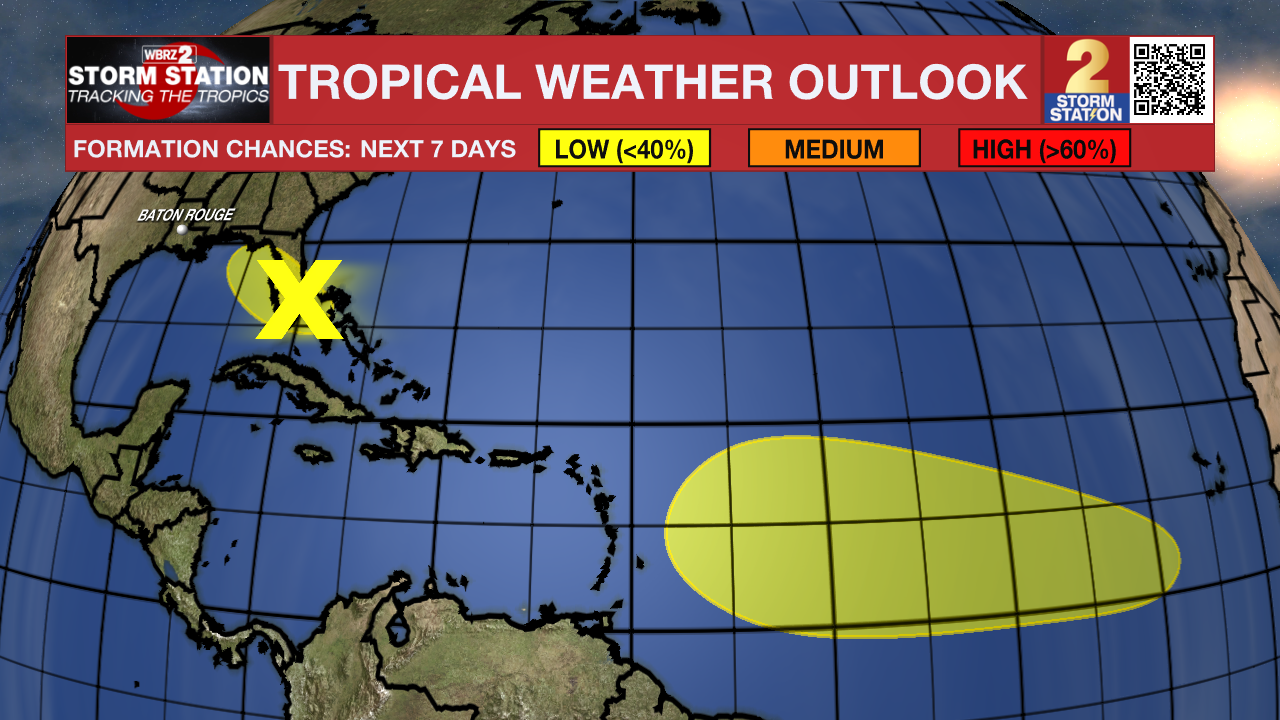
The Tropics: Imelda became post-tropical on Thursday morning. There are now no active systems in the Atlantic Basin. That said, there are a few areas to watch:
Trending News
Southwest Atlantic & Northeast Gulf – An area of low pressure may form along a remnant front near the northwest Bahamas and southern Florida during the next day or two. Any additional development will be slow while the system moves northwestward across Florida and into the Gulf. Tropical formation odds are very low at this time.
Central Tropical Atlantic – A tropical wave will move off the coast of Africa in the next day or so. Thereafter, this wave will interact with another disturbance in the eastern Atlantic. Slow development of the “combined feature” is possible as the system moves west through the tropical Atlantic.
Get the latest 7-day forecast and real-time weather updates HERE.
Watch live news HERE.
— Meteorologist Malcolm Byron
The Storm Station is here for you, on every platform. Your weather updates can be found on News 2, wbrz.com, and the WBRZ WX App on your Apple or Android device. Follow WBRZ Weather on Facebook and X for even more weather updates while you are on the go.
More News
