

Latest Weather Blog
Tuesday PM Forecast: Dry air dialing down storms, but not for long
Temperatures will climb a few degrees higher on Wednesday as drier air noses its way into the Capital Region. Afternoon storms will also have to fight the drying influence, but such a battle will be short-lived as moisture returns in the following days.
Tonight & Tomorrow: Isolated storms will continue a westward drive during the first part of the evening. As rain clears out, so will skies. Sunshine will dominate early Wednesday with a wake-up temperature in the mid 70s. A significant chunk of the atmosphere will dry out for the remainder of the day. Although heat and humidity at the ground may trigger a spotty storm or two, the overlying dry air will help keep these to a minimum. This is great timing for the celebration of the Tigers’ victory at Alex Box Stadium. The few showers that do exist will collapse during the evening as temperatures fall into the 80s. That will feel somewhat nicer after a high near 95° with peak feels-like temperatures in the 100-105° range.
Up Next: The pocket of dry air referenced above will move west on Thursday, opening the door for waves of moisture to return. The source of moisture will come from an upper-level disturbance in the eastern Gulf known as a cutoff low. Such features tend to become stationary, allowing for a multi-day stretch of unsettled weather. While the heart of the system will be centered to the east of the Capital Area, it will be close enough to excite isolated to scattered storms late this week and over the weekend. Keep an eye on the forecast especially with regard to outdoor plans over the weekend. All it would take is a slight shift west with the upper disturbance to nudge rain coverages even higher. Outside of any rain, expect a continuation of the same summer heat and steam. Highs will manage to surpass 90° each and every day.
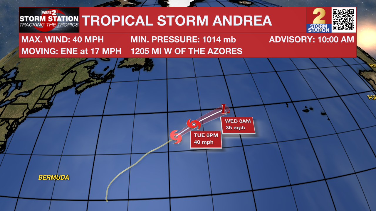
The Tropics: Finally gaining enough organization on Tuesday morning, Tropical Storm Andrea formed in the central Atlantic several hundred miles east of Bermuda. This kicks off the 2025 Atlantic hurricane season after the quietest start since 2014. Andrea will be a very short-lived system and will likely become post-tropical by Wednesday. This storm will remain out to sea with no impacts to land expected.
For the rest of the Gulf, Atlantic, and Caribbean, no development is expected in the next 7 days.
Trending News
Get the latest 7-day forecast and real-time weather updates HERE.
Watch live news HERE.
-- Meteorologist Malcolm Byron
The Storm Station is here for you, on every platform. Your weather updates can be found on News 2, wbrz.com, and the WBRZ WX App on your Apple or Android device. Follow WBRZ Weather on Facebook and X for even more weather updates while you are on the go.
More News
