

Latest Weather Blog
Tuesday PM Forecast: incoming cold front, wind and fall chill expected
Get ready for the most significant temperature turnaround since early April. A strong cold front will leave behind several days of below-average temperatures.
Tonight: passing showers and a spotty severe thunderstorm possible
Wednesday: wind and the first fall chill
End of the Week: crisp and quiet for Halloween
Weekend: sun, comfort, and extra Sleep

Trending News
Tonight & Tomorrow: The incoming cold front will bring a line of showers and thunderstorms into the region this evening. There is even potential for spotty severe thunderstorms. The combination of warm, humid air ahead of the front and strong winds aloft creates an environment where some storms could produce damaging wind gusts or even a brief tornado. The highest potential for these stronger storms will be a short window during the evening hours. Please ensure you have a way to receive weather alerts and have a plan for safe shelter. The biggest change will arrive around sunrise on Wednesday. You are going to feel this one! After waking up to the low 50s, temperatures are only expected to reach the mid-60s during a mainly sunny afternoon, nearly 15 degrees cooler than Tuesday!
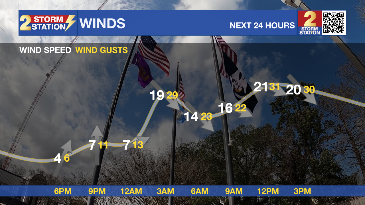
Another factor to consider on Wednesday will be the wind. Expect breezy conditions throughout the day. Commuters should be especially mindful of strong wind gusts (some up to 35-40 mph), particularly if you travel on elevated roadways like bridges or causeways, or will travel downwind of Lake Pontchartrain. Secure any loose outdoor items like Halloween decorations before going to bed on Tuesday so they don’t blow away.
Up Next: Thursday will be crisp and cool, with a morning low in the upper 40s and an afternoon high in the mid 60s. After some morning clouds, plenty of sunshine is expected for the afternoon. Halloween Friday will deliver a morning low in the low 40s—likely the coldest low of the entire period and since early April! If you live in a typically colder spot north and east of Baton Rouge, you might even briefly dip below 40, so protect sensitive plants! Sun will send afternoon highs into the upper 60s. The trick-or-treat forecast calls for crisp and clear conditions with temperatures dropping out of the 60s into the 50s—ideal weather for adding an extra layer beneath those costumes!
The pleasant weather will hold right through the weekend as temperatures begin a slow, comfortable climb. A few high clouds may filter through the skies during the middle of the weekend, but they will not cause any significant disruption. Expect highs in the low 70s and lows in the upper 40s. Don't forget, Daylight Saving Time ends on Sunday morning, so you get an extra hour of sleep as we "fall back" on the clocks.

The Tropics: Hurricane Melissa remained an extremely dangerous storm as of Tuesday afternoon. Catastrophic impacts have been occurring in Jamaica due to wind-driven structural failure, with potential storm surge heights of 9 to 13 feet above ground level along the south coast, and immense rainfall totals of 15 to 30 inches, leading to flash flooding and numerous landslides. Significant hazards, including hurricane-force winds, 10 to 20 inches of rainfall, and a potential storm surge of 8 to 12 feet, are also expected to impact eastern Cuba starting tonight and continuing into Wednesday. The storm’s core will move back into the Caribbean Sea before crossing southeastern Cuba early Wednesday morning and then moving across the southeastern or central Bahamas later on Wednesday.
Get the latest 7-day forecast and real-time weather updates HERE.
Watch live news HERE.
– Josh
The Storm Station is here for you, on every platform. Your weather updates can be found on News 2, wbrz.com, and the WBRZ WX App on your Apple or Android device. Follow WBRZ Weather on Facebook and X for even more weather updates while you are on the go.
More News
