

Latest Weather Blog
Wednesday PM Forecast: first weekend of new month brings shot at needed rain showers
Some gradual changes to the weather pattern will take shape in early October. A weak frontal system will develop near the coast, bringing a chance for showers and thunderstorms.
- End of the Week: spotty showers Thursday, mild
- The Weekend: more unsettled, clouds and showers keep heat in check
- Early Next Week: rain coverage trends down, humidity trends up
Tonight, Tomorrow & Friday: A slight increase in moisture and humidity will allow for a few passing clouds tonight. A spotty, light shower is not even out of the question. Lows will stop in the upper 60s and low 70s. The added moisture will hang around on Thursday as well and could feasibly generate a spotty shower or thunderstorm with the daytime heating of highs in the upper 80s. Otherwise, expect a partly sunny afternoon. Moisture will slack off by Friday, and the chance for showers will fade. Skies will be mainly clear with lows in the upper 60s and highs in the upper 80s.
Friday Night Blitz: For all the high school football games, conditions look cooperative for yet another week. Kickoff temperatures will be in the low 80s, dropping into the mid-70s by the final whistle.
Trending News
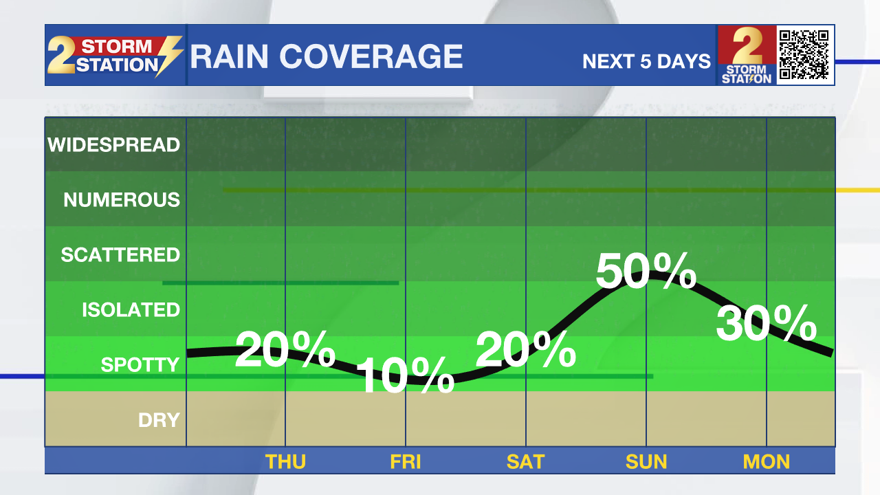
Looking Ahead: Weekend weather will work toward being unsettled. Tropical moisture will once again drift into the atmosphere from the east. As that occurs, a frontal system will develop in the northern Gulf thanks to an upper-level trough, or pocket of cool air in the atmosphere. Initially, showers and thunderstorms will be confined to the coast and locations south and east of Baton Rouge. By late Saturday—and especially Sunday—showers and thunderstorms will be able to develop and drift inland toward Metro Baton Rouge. If you’re planning outdoor events on Saturday, inland areas may stay drier for longer, but the farther south you go, the better chance you’ll have to dodge rain. Sunday could be a little bit more challenging, no matter where you are across south Louisiana and Mississippi. Both days, lows will be in the upper 60s and low 70s, while highs will be in the upper 80s, with Sunday being the cooler of the two days due to added clouds and showers.
By Monday and Tuesday, the frontal system will weaken, causing showers and thunderstorms to once again become more spotty or isolated in nature. High temperatures will rebound into the upper 80s, and a tinge of humidity will hold lows in the upper 60s and low 70s.

The Tropics: Hurricane Imelda, with winds near 100 mph, is moving east-northeast at 20 mph and is expected to bring hurricane-force winds, heavy rain, dangerous waves, and storm surge to Bermuda tonight into early Thursday. The storm is about 270 miles west-southwest of the island and may strengthen slightly before passing close by, then transition into an extratropical system Thursday with gradual weakening afterward. Swells from Imelda will also affect the Bahamas, the U.S. East Coast, and the Caribbean.
Get the latest 7-day forecast and real-time weather updates HERE.
Watch live news HERE.
– Josh
The Storm Station is here for you, on every platform. Your weather updates can be found on News 2, wbrz.com, and the WBRZ WX App on your Apple or Android device. Follow WBRZ Weather on Facebook and X for even more weather updates while you are on the go.
More News
