Friday Evening Video Forecast
Related Story
Rafael will fortunately miss the Capital Area, but moisture from this system will be pulled into the south ahead of a weak front. This will cause rain chances to increase for the weekend.
Scroll down to The Tropics section for the latest on Rafael.
Tonight & Tomorrow: Clouds will stick around in the overnight hours, keeping lows in the low to mid 70's. Saturday will be another muggy and mostly cloudy day. The presence of clouds will keep highs from exceeding the mid 80's. Throughout the day, moisture content in the atmosphere will increase ahead of a weak front. This front will approach the area in the evening hours, causing an increase in rain chances. Timing will be very important with this front, as it will control arrival time of any rain. The current forecast calls for rain chances to steadily increase as we go throughout the evening. Scattered showers and thunderstorms are expected.
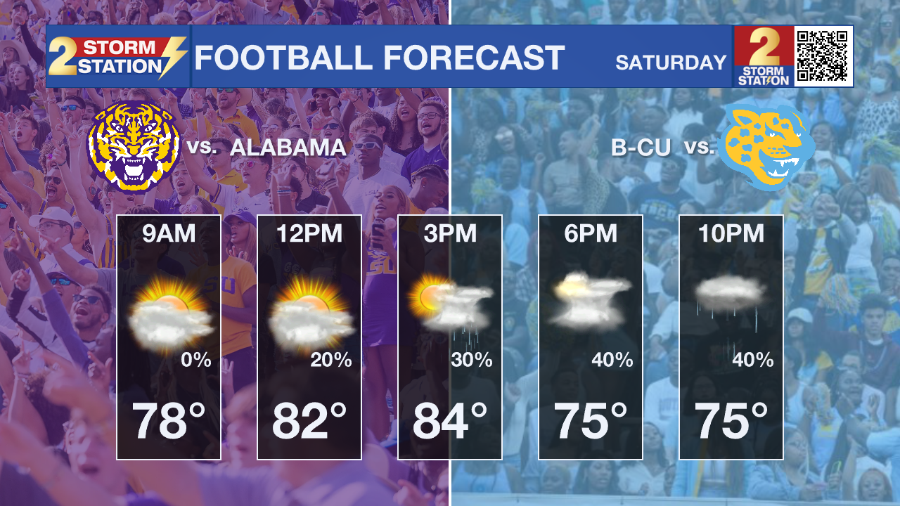
Football Forecast: It is a big weekend of college football with LSU and Southern both playing at home. Southern will kick off in muggy conditions, and temperatures in the 80's. Spotty showers will be around for the start of the game with rain chances increasing as the game goes on. The best chance of rain will likely hold off until the evening and late evening. LSU will kickoff with temperatures in the mid 70's. Rain will be more likely for this game. Timing for the best chance of rain depends on where exactly a weakening front sets up. Rain could arrive right when the game starts, or potentially hold off till the end of the game. The bottom line is rain will be a possibility during the game, so bringing a rain coat or a poncho is a safe bet.
According to the LSU Kickoff Weather Index, the Tigers have won over half of games played in the month of November at home with a kickoff temperature above 70°.

Up Next: Scattered showers and thunderstorms will stick around Saturday night and into the first half of Sunday. This will all be caused by the weakening front mentioned above. This weak cold front will eventually push through the area on Monday afternoon, taking humidity levels down a notch through the middle of the week. Temperatures will still remain warm with highs in the mid 80s, but lower humidity will allow low temperatures to back into the mid 60s; cooler compared to recent days but still way above average. The Storm Station has eyes on a more significant front that looks to pass through later in the week. This has a possibility of lowering highs into the 70's, and lows in the 50's for the rest of the week.
Get the latest 7-day forecast and real time weather updates HERE.
Watch live news HERE.
The Tropics: Rafael rapidly weakened on Friday evening, with maximum sustained wind speeds dropping 30 mph over 6 hours. That was enough for the storm to be downgraded to tropical storm status. This was expected as the storm interacted with lots of wind shear and ingested some dry air. Although the system will meander west and might briefly take a north turn, Rafael will eventually dive south into next week and fizzle out completely in the southern Gulf of Mexico.

The Storm Station is here for you, on every platform. Your weather updates can be found on News 2, wbrz.com, and the WBRZ WX App on your Apple or Android device. Follow WBRZ Weather on Facebook and Twitter for even more weather updates while you are on the go.


