

Latest Weather Blog
Monday evening video forecast
Related Story
Cloud cover will add some “excitement” on Tuesday by perhaps shaving off a few degrees on highs. But the rest of the week looks warm with relatively minor rain chances. In the tropics, Imelda and Humberto continue to stir the southwest Atlantic. Both systems could threaten Bermuda.
Tonight & Tomorrow: With mostly clear skies and relaxing winds, temperatures will fall back into the upper-60s by daybreak. That’s a touch warmer than over the weekend, but it’s not surprising with the warmer afternoons lately. While highs should make a run for 90° on Tuesday, cloud cover will be a wildcard. A wave of cloudiness associated with an upper-level disturbance will arrive during the day. Depending on their arrival time and thickness, temperatures might even struggle to rise out of the 80s. Although guidance isn’t too optimistic for rain, the pattern supports a spotty sprinkle or two. Even so, they will not be significant or widespread.
Up Next: Skies will trend sunnier through the remainder of the workweek. A weak disturbance may squeeze out the occasional shower or storm on any given day — but especially Thursday. Temperatures will run close to or slightly above average, with afternoons in the upper 80s and mornings in the mid-to-upper 60s. As for the weekend forecast, it’s proving to be a challenge. There are signs of a storm system possibly spinning up along the coast. But exactly where is the tricky part, and it’s still too far out to pinpoint its location. If making weekend plans, be prepared to face spotty showers and storms. However, keep an eye on the forecast. Rain chances might have to go up if the storm system draws more moisture into the region.
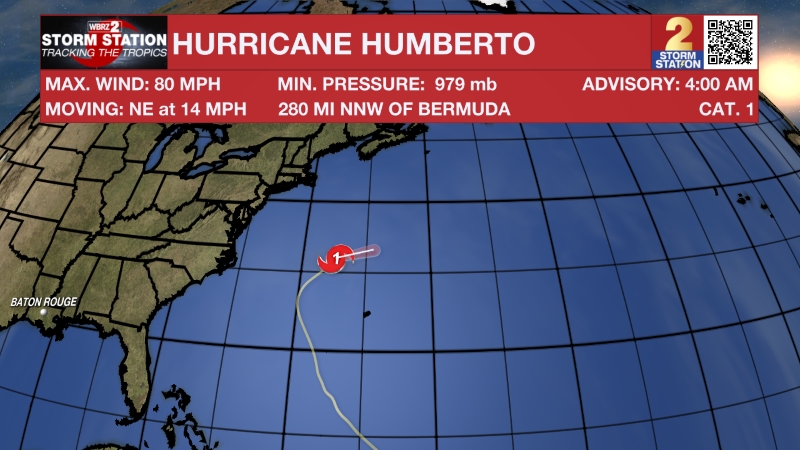
The Tropics: Humberto remains a powerful Category 4 hurricane in the southwest Atlantic. Its wind field is expanding also, and that could be problematic for Bermuda. Although the core of the storm will easily miss the island chain to the northwest, tropical storm-force winds might clip the region on Tuesday. As for U.S. impacts, Humberto will cause dangerous surf and rip currents along the East Coast throughout the remainder of the week.
Meanwhile, Tropical Storm Imelda continues to strengthen and will likely become a hurricane by Tuesday. Positioned just north of the Bahamas, Imelda sits very close to the U.S. East Coast as of Monday afternoon. However, the storm will make a sharp turn to the east-northeast, away from the U.S., in the coming days. Such a track would threaten Bermuda, where a direct strike is not off the table. Heavy rainfall, flooding, and even hurricane-force winds will be possible on Wednesday.

Get the latest 7-day forecast and real-time weather updates HERE.
Watch live news HERE.
— Meteorologist Malcolm Byron
The Storm Station is here for you, on every platform. Your weather updates can be found on News 2, wbrz.com, and the WBRZ WX App on your Apple or Android device. Follow WBRZ Weather on Facebook and X for even more weather updates while you are on the go.
News
