Monday Midday Video Forecast
Related Story
The new workweek brings the same Louisiana summertime heat! Expect hot days with a scattering of storms each afternoon. Storms will become more numerous by the end of the week as a weak front moves into the region.
Today & Tonight: Monday will be another hot one, with highs in the mid-90s. Factoring in the humidity, it will feel more like 105–108°, which is just shy of heat alert criteria but still hot enough to be dangerous if you’re outdoors too long. The day begins mostly sunny, but clouds will build through the afternoon, leading to scattered downpours and thunderstorms across the region in the late afternoon/early evening hours. After sunset, storms will fade, skies will clear, and overnight lows will settle in the mid-70s.
Up Next: Typical summertime weather sticks around through midweek with hot, sunny days and a few isolated afternoon storms. Tuesday and Wednesday may bring fewer storms as slightly drier air moves in aloft. By late week, a weak front pushing into Louisiana will help spark more widespread thunderstorms Thursday and Friday. Even with rainier afternoons, mornings will stay warm and sunny, allowing highs to reach the low 90s before storms provide only brief relief. Unfortunately, this front does not look to bring much change in temperatures or humidity to south Louisiana.

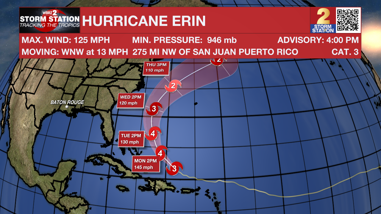
Hurricane Erin: Erin holds steady as a powerful Category 3 hurricane Monday morning, tracking WNW just north of Puerto Rico with peak winds near 125 mph. The storm is likely to re-strengthen into a Category 4 storm later today, with winds approaching 145 mph. The latest model guidance shows a slight westward shift in its path, though the system is still projected to turn mainly northward through the week. Erin is also expanding in size, meaning rough seas and stronger winds will reach farther from the storm’s center across the western Atlantic. At this time, no direct landfall is expected for the East Coast or Bermuda.
Tropical Atlantic: A large area of disorganized showers and thunderstorms over the eastern tropical Atlantic is associated with a tropical wave. Environmental conditions appear conducive for gradual development of this system, and a tropical depression could form during the latter part of the week while moving westward to west-northwestward at about 20 mph across the central tropical Atlantic, possibly approaching the vicinity of the Leeward Islands on Friday.
Get the latest 7-day forecast and real-time weather updates HERE.
Watch live news HERE.
– Emma Kate C.
The Storm Station is here for you, on every platform. Your weather updates can be found on News 2, wbrz.com, and the WBRZ WX App on your Apple or Android device. Follow WBRZ Weather on Facebook and X for even more weather updates while you are on the go.


