

Latest Weather Blog
Sunday Evening Video Forecast
Related Story
The new workweek will start off warm and quiet. A few changes will come for the rest of the week, although their impact will be somewhat minor. Meanwhile, the tropics remain active with Humberto and newly-named Imelda churning in the southwest Atlantic.
Tonight & Tomorrow: Sunday night will be calm and comfortable under a mostly clear sky. Overnight lows will dip into the mid-60s, right on pace with the average for late September. Sunshine will continue to dominate on Monday, all thanks to an area of high pressure staying in control. That will also allow for a fast temperature climb. Look for an afternoon high in the lower 90s. Though still quite toasty, at least the humidity will remain in the comfortable realm.
Up Next: An upper-level disturbance will swing through the area on Tuesday, but its impact will be minor. A sizable portion of the atmosphere will be too dry to support an abundance of showers. Rather, rain will be limited to a spotty sprinkle or two. More notably, clouds will increase throughout the day. Highs may get held back by a degree or two in response. Skies will trend sunnier as cloud cover takes a backseat Wednesday through Friday. But still, an overlying weak disturbance could ring out a spotty t-shower or two on occasion. Temperatures will be close to or slightly above average, with highs in the upper 80s to low 90s and lows in the mid to upper 60s.
For next weekend, forecast confidence is low at this time. There are some signs of an area of low pressure developing by the coast. That could result in a sharp uptick in rain chances for the weekend, depending on the system’s placement. And that’s the tricky part — it’s still a little far out to pinpoint where it will be. For now, be prepared for the possibility of spotty showers and storms next weekend; however, check back later in the week as the forecast becomes further refined.
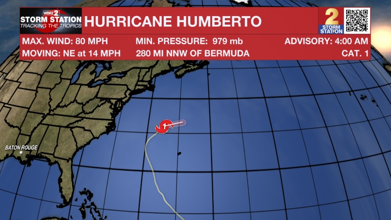
The Tropics: Imelda became the ninth-named storm of the 2025 Atlantic hurricane season on Sunday. Forming by the Bahamas, the storm just barely met tropical storm criteria with maximum sustained winds at 40 mph. Imelda will strengthen as it moves north over the next day or so. Now that the system has formed, computer model guidance is getting a better handle on where the system will go. Most data now show Imelda slowing several hundred miles offshore the Southeast U.S. on Monday before accelerating east out to sea. Such a scenario would limit major impacts for the United States. However, this track would push Imelda closer to Bermuda by midweek — and possibly as a hurricane. That would come shortly after Bermuda’s close call with Gabrielle and Humberto.

Although Humberto has weakened slightly from its Category 5 peak, it remains a formidable Category 4 hurricane as of Sunday afternoon. The storm will likely remain a major hurricane through Monday as it continues northward through the Atlantic. Humberto will take a northeastward turn by midweek, steering the hurricane away from the United States. However, the system will come close to Bermuda. Although the core of the system will likely miss the island to the north, it may pass close enough to bring tropical storm-force conditions by late Tuesday.
Get the latest 7-day forecast and real-time weather updates HERE.
Watch live news HERE.
— Meteorologist Malcolm Byron
The Storm Station is here for you, on every platform. Your weather updates can be found on News 2, wbrz.com, and the WBRZ WX App on your Apple or Android device. Follow WBRZ Weather on Facebook and X for even more weather updates while you are on the go.
News
