

Latest Weather Blog
Wednesday evening video forecast
Related Story
If you are planning an egg hunt or outdoor gathering this weekend, Saturday looks like the best bet for dry conditions. Have a backup plan for Sunday just in case, as some showers and thunderstorms will be around.
Here is a breakdown of what to expect
• Thursday: sunny, dry, and mild — classic spring weather
• Friday–Saturday: warmer, more humid, breezy, and cloudier but still dry
• Easter Sunday–Monday: rain and thunderstorms possible, no severe weather expected
• Tuesday & Wednesday: trending drier, but a low confidence forecast
Tonight & Tomorrow: Overnight will stay mainly clear with low temperatures visiting the upper 50s, not as chilly as last night due to a wind shift. High pressure will shift east on Thursday, allowing southerly winds to return. Highs will climb into the mid-80s, beneath mostly sunny skies. Humidity starts to creep up, but it won’t be too noticeable just yet.
Easter Weekend: The warming trend will continue on Friday. Expect highs in the upper 80s, and some spots could even flirt with 90°F. It will start to feel a little less comfortable as well due to an increase in humidity, thanks to south winds of 10-15 mph. Cloud cover will start to build, especially by late afternoon.
Saturday morning will be noticeably more muggy than recent days, beginning in the upper 60s. A mostly cloudy and breezy afternoon will follow, but it will remain dry. Extra clouds compared to Friday may keep highs a degree or two cooler, but we’ll still see highs in the mid to upper 80s.
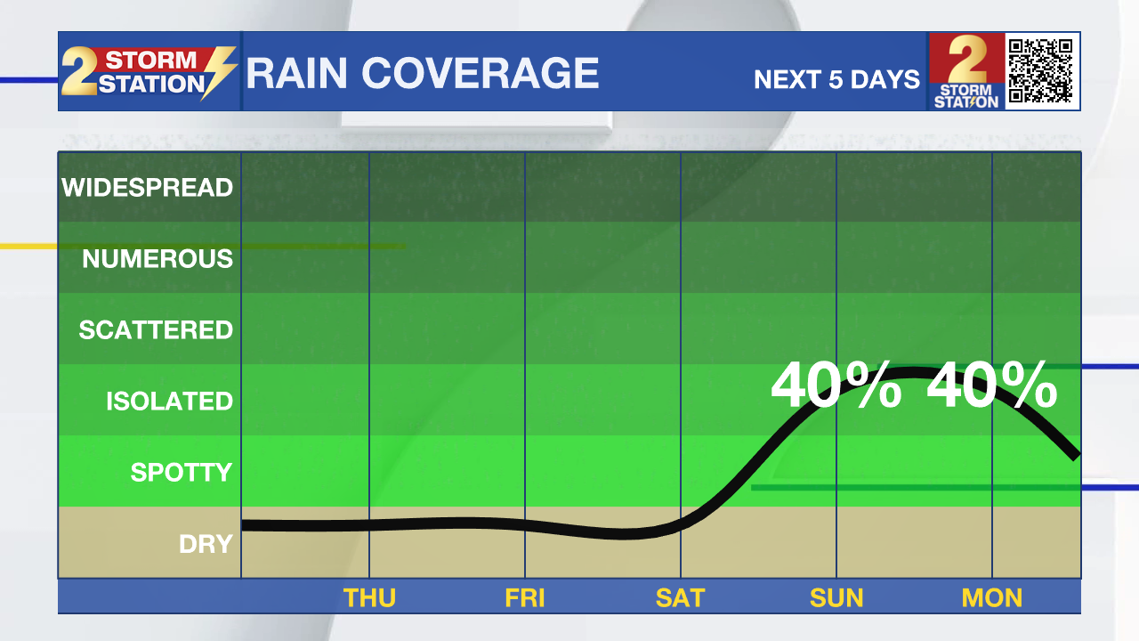
The increased humidity will keep Sunday morning closer to 70°F. A developing storm system to our west will push into the region. Isolated showers and thunderstorms will be in play by the afternoon and evening. With about 40% coverage in measurable rain, not everyone will get wet, but be prepared for possible brief downpours, some gusty winds, and lightning, especially west of I-55 and north of I-10. Severe weather is not expected. More high-resolution data will help refine the forecast as we approach the weekend, so check in for updates. Otherwise, expect mostly cloudy, breezy, and humid conditions as highs top out in the mid-80s.
Up Next: Confidence is lower than usual in the extended forecast due to a weak front stalling and weakening in the region. This feature will maintain the possibility of showers and thunderstorms for a few days into next week, but timing more active periods is not possible until we get closer.

River Flooding: The National Weather Service has issued a RIVER FLOOD WARNING for the Mississippi River at Red River Landing and Baton Rouge until further notice. In addition, a RIVER FLOOD WARNING will go into effect on Monday, April 21 for the Atchafalaya River at Morgan City.
• At Red River Landing, flood stage is at 48 feet. Minor flooding is already occurring. Moderate flooding is expected with a crest near 57 feet. Around these levels, Angola farmland on the left bank begins taking on water. Caution is urged when walking near riverbanks. The river will crest by April 25, then fall below flood stage by May 4.
• At Baton Rouge, flood stage is 35 feet. Minor flooding has already begun. Major flood stage will be reached on April 25 with a height of 40.5 feet. Levels will fall below flood stage around May 3. Around these levels, the grounds of the older part of Louisiana State University's campus become soggy. This includes the area around the Veterinary Medicine building, the Veterinary Medicine Annex, and Alex Box Stadium. Levees protect the city of Baton Rouge and the main LSU campus at this level. Caution is urged when walking near riverbanks.
• At Morgan City, flood stage of 6 feet may be reached on Monday. Moderate flooding with a crest of 7.5 feet is forecast by April 27. At 7 feet, buildings at the foot of Ann Street on the river side of the flood wall will flood as water overtops the Rio Oil Company dock. Buildings on the river side of the Berwick floodwall will flood. River traffic restrictions will be strictly enforced. In addition, backwater flooding could potentially impact portions of areas around Lake Palourde and Stephensville.
The National Weather Service has issued a RIVER FLOOD WATCH for the Atchafalaya River at Simmesport and Butte La Rose until further notice.
• At Simmesport, flood stage of 40 feet may be reached by April 26. There will be flooding of areas inside the levees of the Atchafalaya Floodway and considerable flooding in the backwater storage area in Avoyelles Parish.
• At Butte La Rose, flood stage of 20 feet may be reached by April 27. Minor flooding of the nearby areas could occur.
Get the latest 7-day forecast and real-time weather updates HERE.
Watch live news HERE.
– Josh
The Storm Station is here for you, on every platform. Your weather updates can be found on News 2, wbrz.com, and the WBRZ WX App on your Apple or Android device. Follow WBRZ Weather on Facebook and X for even more weather updates while you are on the go.
News
