

Latest Weather Blog
Wednesday evening video forecast
Related Story
Rounds of showers and thunderstorms will remain possible into Thursday before a much-awaited cold front arrives. Much more comfortable conditions are expected for Friday and beyond.
Tonight & Tomorrow: We will have a break in the showers and thunderstorms this evening. Skies will stay mainly cloudy, and lows will be muggy in the low to mid 70s. Another round of scattered showers and thunderstorms is expected to fire up early Thursday morning, possibly lasting into midday—especially south of I-10. Be aware of the potential for some stormy weather on the commute into work and school, as that could cause delays. The silver lining is that the clouds and rain will keep our temperatures a bit cooler on Thursday, with highs in the mid-80s. The “main event” that we have been tracking—a much-anticipated cold front—will start to push through during the afternoon, with winds shifting out of the north, skies clearing, and humidity falling.
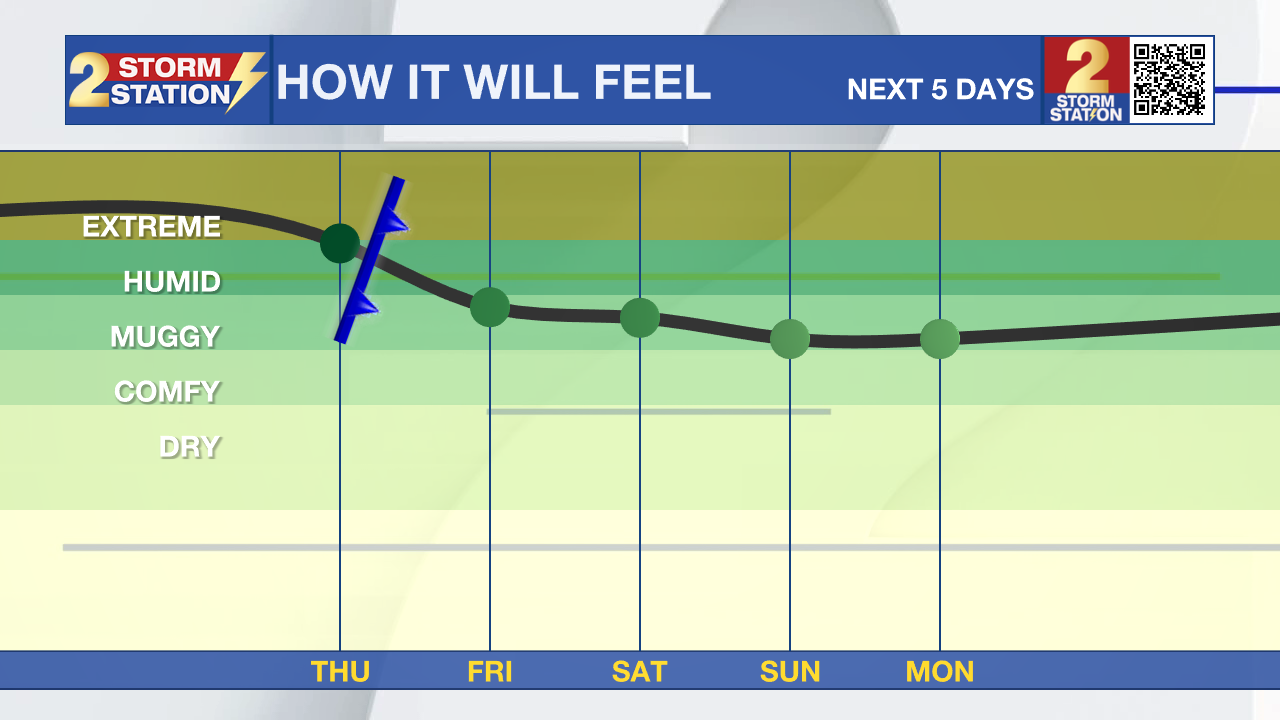
Up Next: Expect a big difference in overnight lows for the next several mornings. Friday will begin in the upper 60s and warm into the mid-80s despite almost full sun. A stray shower will remain possible near the coast, but that will be the exception rather than the rule. Expect a pleasant evening for high school football with temperatures falling out of the 80s into the 70s.
The weekend is looking very cooperative for outdoor plans, including Southern Football. Surface high pressure will build in behind the front, giving us two days of clear skies. Highs on Saturday and Sunday will climb to a warm 88 and 89 degrees, respectively, which is right around normal for this time of year. Best of all, the humidity will be way down, allowing overnight lows to dip into the comfortable low to mid-60s.
The quiet and comfortable pattern will continue into next week with highs around 90 degrees and lows in the upper 60s. By Wednesday, a stray shower may become possible, but as of now the forecast only carries 10% coverage.

The Tropics: Hurricane Gabrielle is a powerful storm moving eastward across the subtropical Atlantic. It is located about 1100 miles west of the Azores with maximum sustained winds of 110 mph. The storm is expected to weaken slightly but will still be a hurricane when it passes near or over the Azores late Thursday or early Friday. A Hurricane Warning is in effect for all of the Azores, where hurricane conditions, including strong winds, dangerous storm surge, and coastal flooding, are expected. The storm is also forecast to bring 3 to 5 inches of rain to the central and western Azores.
Additionally, Tropical Storm Humberto formed in the central Atlantic Ocean on Wednesday afternoon. The system is expected to stay on a track northwestward. While it will not threaten the Gulf Coast, Bermuda will need to monitor its progress.
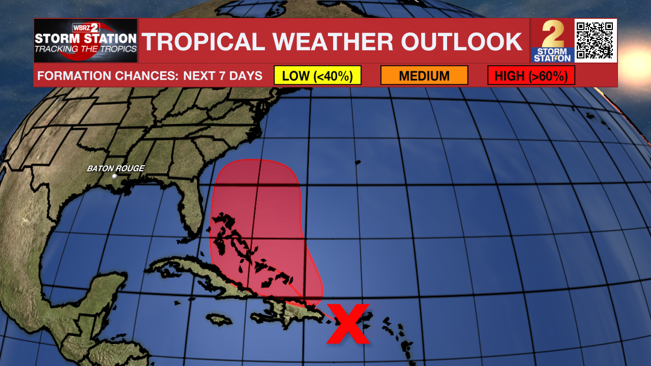
Another tropical wave west of Humberto is bringing heavy rain and gusty winds to Puerto Rico and the Dominican Republic. The system is likely to develop into a tropical depression as it approaches the Bahamas later this week. The United States East Coast will have to keep an eye on it.
Get the latest 7-day forecast and real-time weather updates HERE.
Watch live news HERE.
– Josh
The Storm Station is here for you, on every platform. Your weather updates can be found on News 2, wbrz.com, and the WBRZ WX App on your Apple or Android device. Follow WBRZ Weather on Facebook and X for even more weather updates while you are on the go.
News
