

Latest Weather Blog
Fog possible Friday morning ahead of high-end severe weather threat Saturday
A strong storm system brings the threat of severe weather across the southeastern United States this weekend, moving through southern Louisiana on Saturday. Sunny and quiet conditions will return Sunday.
A DENSE FOG ADVISORY is in effect until 11 am Friday for the entire viewing area. Visibility may be reduced to one-quarter mile or less due to fog and could create hazardous driving conditions. Drivers are advised to slow down, use low-beam headlights, and maintain a safe distance from other vehicles.
Today & Tonight: A mild and muggy morning across the region hints at the changes to come this weekend. With more moisture in the atmosphere, clouds early Friday may sink to ground level, resulting in low visibilities across the Capital Area, especially over bridges and other elevated surfaces. Mostly cloudy skies will remain all day with a few peeks of the sun this afternoon. Look for morning lows in the 60s and highs in the 80s. Rain and a few rumbles of thunder cannot be ruled out Friday afternoon and evening as our next storm system nears. Bring raingear if you are heading to Alex Box Stadium today or have any outdoor plans. Winds will also be noticeably breezier today, kicking out of the south between 15-25 mph with higher gusts at times.
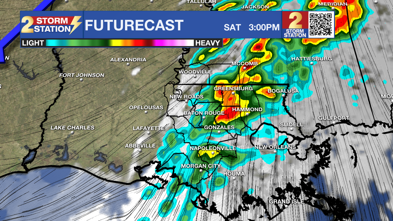
Saturday: Saturday is shaping up to be a stormy day across southern Louisiana and Mississippi. A strong weather system will move through from the morning into the early afternoon hours, bringing widespread showers and thunderstorms. Some of these storms could be severe, with the potential for damaging winds, hail, and tornadoes. The Storm Prediction Center has assigned an uncommon (1-2 times per year, locally) Level 4/5 “Moderate Risk” of severe weather for the majority of the Capital Area, including Baton Rouge, Hammond, New Roads, Gonzales and Napoleonville to name a few cities. Generally, this means numerous severe thunderstorms are expected within the risk area, and some storms could be particularly intense. The system is expected to move quickly, so the worst of the weather will likely be during the first half of the day. By the evening, the front should push east, bringing much quieter conditions.
Trending News
Click HERE to watch WBRZ streaming live online
Click HERE for the WBRZ weather page.
Click HERE to see how to download the WBRZ weather app.
With the potential for severe storms on Saturday, it’s important to stay in touch with the Storm Station. Download our free app to get continuously updated forecasts and breaking weather alerts like watches and warnings. Review severe weather plans so you know what to do when thunderstorms threaten.
Up Next: Just in time for 40th Wearin’ of the Green Parade and St. Patrick’s Day festivities, Sunday will bring a major shift in the weather—cooler, drier air will settle in, dropping highs to a comfortable 73°F with plenty of sunshine. Monday and Tuesday look fantastic as well, with highs in the mid to upper 70s under mostly sunny skies. By Wednesday, temperatures will climb back to 80°F, with just a slight chance of rain returning.
Get the latest 7-day forecast and real-time weather updates HERE.
Watch live news HERE.
– Storm Station Team
The Storm Station is here for you, on every platform. Your weather updates can be found on News 2, wbrz.com, and the WBRZ WX App on your Apple or Android device. Follow WBRZ Weather on Facebook and X for even more weather updates while you are on the go.
Posts below are from the WBRZ Weather X account. Monitor for weather warnings below.
More News
