

Latest Weather Blog
Friday AM Forecast: Strong storms possible to start weekend, Dip in humidity to finish
Heads up! Showers and storms will move in Friday and peak overnight into early Saturday. Some storms could be strong, so keep an eye on the forecast if you have evening plans.
Today & Tonight: Friday will be largely dry until the late afternoon and early evening hours. Look for a mix of sun and clouds with a steamy afternoon in the 80s. Coverage of showers and storms will gradually increase as the afternoon wears on. Those with Friday night dinner plans or other activities will need to keep rain gear handy and monitor the forecast. Storm activity is likely to peak overnight and early Saturday as a wave of energy refuels the atmosphere to support storm development. At any time over the 36 hours, isolated instances of severe weather will be possible. High wind gusts, periods of downpours, and hailstorms remain the highest threat with this system.
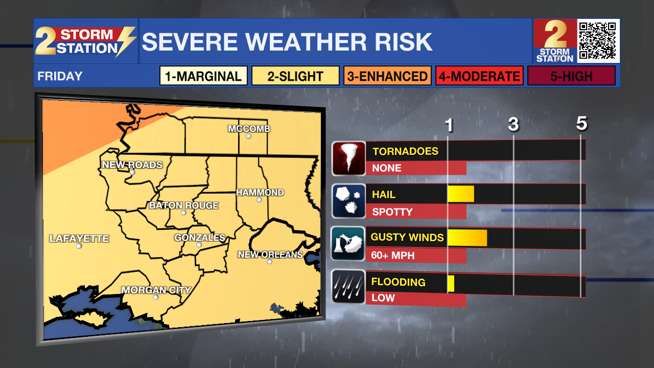
Saturday: Clouds and showers will keep temps around 80° on Saturday, but the day won’t be a total washout. Expect rain and storms early Saturday morning, to gradually quiet down around midday. Saturday afternoon, a cold front will roll through, bringing a few more isolated thunderstorms before delivering dry air for the second half of the weekend.
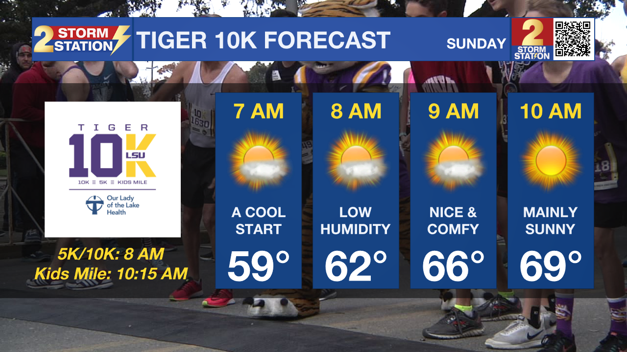
Up Next: Dry air behind the cold front Saturday night will clear skies and drop humidity levels. Sunday will be very nice with a cooler start in the upper-50s and an afternoon high close to 81° under mainly sunny skies in the Capital Area. Those racing in the Tiger 10k Sunday morning should enjoy the refreshing air. Monday will see similar conditions before humidity quickly returns on Tuesday. The return of humid conditions next week will also accompany the return of unsettled weather.
Trending News
River Flooding: The National Weather Service has issued a RIVER FLOOD WARNING for the Mississippi River at Red River Landing, Baton Rouge, Donaldsonville, and Reserve, as well as the Atchafalaya River at Morgan City.
• At Red River Landing, flood stage is at 48 feet. The river has crested at around 59.5 feet with levels holding steady for now. This is in moderate flood stage. At this level, the east bank levee will be topped, and the prison farmland between the two levees will be inundated. Angola Landing will be under water, closing the ferry there. All river islands along the reach from Red River Landing to Baton Rouge will remain inundated with recreational camps and river bottom farmland under water. This gauge will fall below flood stage around May 14.
• At Baton Rouge, flood stage is 35 feet. The river has crested at around 42.3 feet with levels holding steady for now. This is in major flood stage. Around these levels, the grounds of the older part of Louisiana State University's campus become soggy. This includes the area around the Veterinary Medicine building, the Veterinary Medicine Annex, and Alex Box Stadium. Levees protect the city of Baton Rouge and the main LSU campus at this level. Caution is urged when walking near riverbanks. This gauge will fall below flood stage around May 12.

• At Donaldsonville, the flood stage is at 27 feet. The river has crested at around 30.8 feet with levels holding steady for now. This is in moderate flood stage. Around these levels, navigation becomes difficult for smaller river craft. Safety precautions for river traffic are urged. After cresting, the river will fall below flood stage around May 10.
• At Reserve, flood stage is at 22 feet. The river has crested at around 23.7 feet with levels holding steady for now. This is just shy of moderate flood stage. Around these levels, slow-bell procedures will be enacted for river transportation. After cresting, the river will fall below flood stage around May 9.
• At Morgan City, flood stage is at 6 feet. The river has crested at around 6.6 feet with levels holding steady for now. This is in minor flood stage. At 6 feet, the city dock will be under water. Water will cover the lower end of Belleview Front Street in Berwick. Vessel traffic will be affected by stronger river currents. Vessel traffic safety rules will be strictly enforced by the U.S. Coast Guard. The river will fall below flood stage around May 9.
Get the latest 7-day forecast and real-time weather updates HERE.
Watch live news HERE.
- Emma Kate C.
The Storm Station is here for you, on every platform. Your weather updates can be found on News 2, wbrz.com, and the WBRZ WX App on your Apple or Android device. Follow WBRZ Weather on Facebook and X for even more weather updates while you are on the go.
More News
