

Latest Weather Blog
Saturday PM Forecast: staying very warm, high chance of tropical development in Gulf
We will stick with the above average temperatures and dry conditions to conclude the weekend. There is now a high chance that a tropical system will develop in the Gulf of Mexico next week.
Tonight & Tomorrow: Any clouds that we saw today we quickly clear out as we head into the overnight hours. This will allow our lows to get into the lower 70's. A few areas of patchy fog cannot be ruled out closer to daybreak. It will be rinse and repeat in the world of weather for tomorrow. Highs will get into the mid 90's, with feels like temperatures 100°+. Sunscreen will be a must if outside for any extended period. Also make sure to hydrate frequently.
Up Next: The first full week of fall will feature a mix of sun and clouds, highs in the low to mid 90's, and slight chances of rain. Humidity will cause feels like temperatures to be near 100°. Nights will be muggy and slightly uncomfortable with lows in the low 70s.
The forecast gets a little tricky by the middle and end of the week. The two key features will be an approaching cold front to the north and a tropical disturbance to the south. How these features interact will affect our forecast. If we get a clean front passage, this will protect us from the tropical disturbance, and deliver cooler temperatures late in the week. If the front stalls to the north, there would no shield if this disturbance decides to come our way. Details about the track are still uncertain (see below). Expect some changes to the forecast and stick with the Storm Station for those updates.
Get the latest 7-day forecast and real time weather updates HERE.
Trending News
Watch live news HERE.
The Tropics: A broad area of low pressure is likely to form by the early to middle part of next week over the northwestern Caribbean Sea and the adjacent portions of Central America. Thereafter, gradual development of this system is possible, and a tropical depression could form as the system moves slowly to the north or northwest over the northwestern Caribbean Sea and across the Gulf of Mexico through the end of next week.
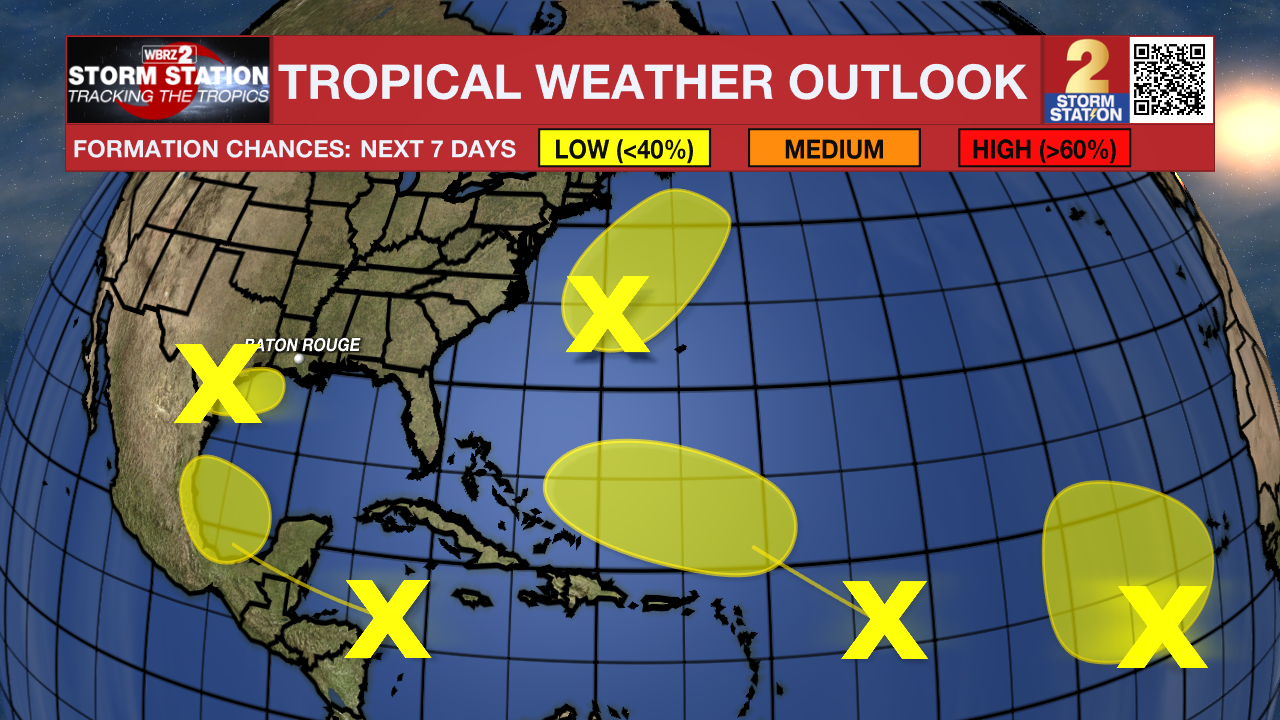
Strong upper-level winds continue to keep showers and thunderstorms displaced away from the center of an area of low pressure (the remnants of Gordon) located over one thousand miles southwest of the Azores. Significant development of this system is not expected while it moves slowly northwestward over the central subtropical Atlantic during the next couple of days.
An area of low pressure located about 700 miles southeast of Bermuda continues to produce a small cluster of showers and thunderstorms northeast of its center. However, the low is embedded in a very dry environment, and therefore significant development is not expected while it moves generally northward at 5 to 10 mph over the central subtropical Atlantic.
A tropical wave is expected to move westward from the coast of Africa on Sunday or Monday. Gradual development of this system is possible thereafter, and a tropical depression could form next week while the wave moves westward across the eastern and central tropical Atlantic.
– Balin
The Storm Station is here for you, on every platform. Your weather updates can be found on News 2, wbrz.com, and the WBRZ WX App on your Apple or Android device. Follow WBRZ Weather on Facebook and Twitter for even more weather updates while you are on the go.
More News
