

Latest Weather Blog
Thursday PM Forecast: tracking two fronts in ahead of Thanksgiving
The next seven days will be marked by continued unseasonable warmth and a more active weather pattern with a couple of rain chances. While we won't be seeing any major storm systems, a few weak cold fronts will try to sneak through to move temperatures down.
Tonight & Tomorrow: The first of two weak cold fronts will approach the region overnight. As this happens, cloud cover and winds will increase — just enough of a breeze to avoid another episode of fog. Isolated showers will become possible into the morning hours. If you're heading out for work or school on Friday, grab an umbrella and be prepared to use the windshield wipers occasionally. Do not expect a washout or any significant rainfall amounts. In fact, some sun should be around in the afternoon with highs still in the 80s. A few storms could take advantage of the afternoon sun, but will generally be spotty in nature.
.png)
Friday Night Blitz: Leftover showers will be wrapping up through the evening. You could take rain gear as a precaution, but chances are that you will not need it. Temperatures will be on the warm side for November; expect readings in the upper 60s to low 70s.
The Weekend: As a weak front falls apart while slipping south through the region, our old friend — fog — might make a return at the beginning of the weekend before it passes. Additionally, a remnant shower or two is possible on Saturday, but that chance diminishes as the air dries out on Sunday. Otherwise, well above-average temperatures will continue with highs in the low 80s, and lows in the low 60s Saturday and perhaps the upper 50s Sunday.
Trending News
LSU Tailgating & Game Day: Some fog could be around during the morning tailgate setup, but that should dissipate by 9 – 10 a.m. as temperatures climb away from the mid-60s. The afternoon will warm into the low 80s with partly sunny skies. Don’t be shocked by a brief shower, but most of the day will be dry. By game time, temperatures will settle back into the 70s and possibly reach the 60s before the final whistle.
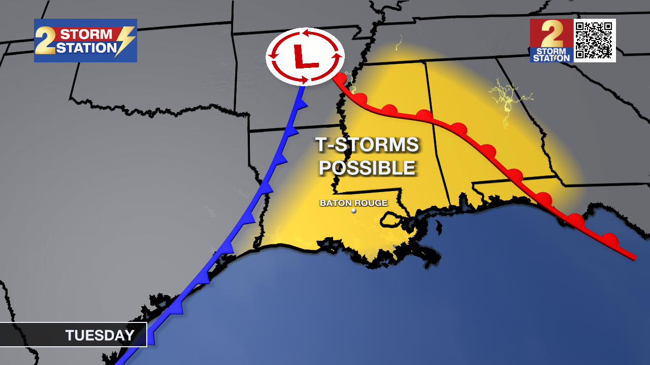
Thanksgiving Week: The warmth hangs on into the start of next week, but another chance for rain will be on the way as a second weak cold front approaches. Monday night and into Tuesday, that front will bring showers and thunderstorms with perhaps slightly more rainfall than the first front. This front will take a bit more of a toll on temperatures as well, sending highs back into the 70s on Wednesday. A more substantial surge of cool air will follow about 24 hours later, with average to below-average temperatures arriving for Thanksgiving and Black Friday — both days look to have highs in the 60s.
The Tropics: For the Gulf, Caribbean, and Atlantic, all is quiet. No new tropical development is expected over the next seven days.
Get the latest 7-day forecast and real-time weather updates HERE.
Watch live news HERE.
– Josh
The Storm Station is here for you, on every platform. Your weather updates can be found on News 2, wbrz.com, and the WBRZ WX App on your Apple or Android device. Follow WBRZ Weather on Facebook and X for even more weather updates while you are on the go.
More News
