

Latest Weather Blog
Friday AM Forecast: Mainly dry for football action, rain chances increase next week
Only a few stray showers are expected the next few days, so high school football, and LSU football will be good to go! Starting next week, increasing available moisture will lead to more showers and storms.
Today & Tonight: Thursday's weather will continue into today. That means expect mostly sunny skies, hot temperatures in the 90s, and mainly dry conditions. Rain coverage is only around 10%, so while it's not impossible you see a shower, it's very unlikely. Overall, the weather will cooperate for some Friday night football action. It will be warm, mainly dry, with a touch of humidity.
LSU Football: Fans heading to LSU on Saturday can look forward to another hot and mostly sunny day, with afternoon highs topping out in the low 90s. Just like last weekend, it’ll be important to pack sunscreen, stay hydrated, and find shade when you can. Rain chances sit around 10%, meaning most will stay dry, though a stray shower can’t be ruled out. Even after kickoff, the humidity sticks around, with temperatures slowly easing from the 90s into the lower 80s by evening.
Up Next: This weekend looks steady with little change in the overall pattern. While a stray shower can’t be ruled out Saturday or Sunday, the vast majority of outdoor activities should go on without weather issues. Temperatures will stay hot during the afternoons, topping out in the low 90s, while mornings start comfortably in the upper 60s to near 70.
By Monday, the calendar flips to fall, and the atmosphere will follow suit with a more active setup. A few disturbances aloft will spark showers and storms through midweek, with daily coverage running around 30–50%. Most areas are likely to pick up rain at least once during that stretch. With the added clouds and rainfall, afternoon highs should ease back closer to normal, settling in the upper 80s.
Trending News
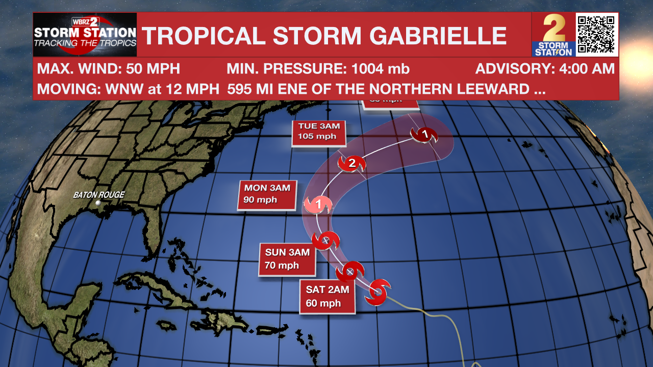
The Tropics: Tropical Storm Gabrielle is holding steady with winds around 50 mph as it continues moving west-northwest at about 10 mph. The storm is expected to gradually strengthen over the next few days, likely reaching hurricane strength by Sunday. Current forecasts keep Gabrielle’s center at least 140 miles east of Bermuda in about three days, but the island could still feel some impacts since winds and rain extend far from the center. Gabrielle should strengthen through the weekend before running into stronger winds and cooler waters next week, which will likely cause it to weaken.
A tropical wave just off the west coast of Africa is producing disorganized shower and thunderstorm activity. Some slow development of this system is possible through the middle to latter part of next week while it moves west-northwestward across the eastern and central tropical Atlantic.
Get the latest 7-day forecast and real-time weather updates HERE.
Watch live news HERE.
– Balin
The Storm Station is here for you, on every platform. Your weather updates can be found on News 2, wbrz.com, and the WBRZ WX App on your Apple or Android device. Follow WBRZ Weather on Facebook and X for even more weather updates while you are on the go.
More News
