

Latest Weather Blog
Friday PM Forecast: better chance for beneficial rain next week
Skies will stay mainly clear overnight with lows dipping into the upper 60s and low 70s. After the weather pattern holds steady through the weekend, there is potential for a few more showers and thunderstorms next week.
Friday Night Blitz: Skies will be mostly clear with just a few passing clouds and no significant rain concerns. Temperatures will start in the upper 80s for kickoff, but quickly cool into the upper 70s by the second half of the games. We can call this warm but comfortable with a light breeze.
LSU Football: If you are heading to LSU on Saturday for tailgating or the game, expect a mostly sunny and hot day with highs in the low 90s. Much like last weekend, sunscreen, hydration, and breaks in the shade will be key for tailgaters. Rain coverage of only about 10% is expected, so it’s unlikely that showers will interfere. It will stay sticky through kickoff into the evening with temperatures dropping out of the 90s into the low 80s.
Up Next: For the weekend as a whole, the pattern will not change much. Saturday and Sunday both bring a non-zero chance for showers, but most outdoor plans and weekend events should stay dry. Highs will hover in the low 90s, with mornings in the upper 60s. By Monday, the calendar flips to fall. The atmosphere will try to follow suit with a flip of its own. A few disturbances aloft will spark showers and storms through midweek, with daily coverage running around 30–50%. Most areas are likely to pick up rain at least once during that stretch. With the added clouds and rainfall, afternoon highs should ease back closer to normal, settling in the upper 80s.
Trending News
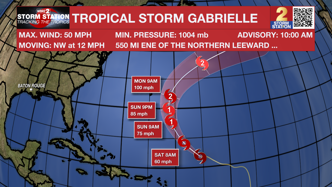
The Tropics: Tropical Storm Gabrielle is currently located about 550 miles east-northeast of the Northern Leeward Islands. The storm has maximum sustained winds of 50 mph and is moving northwest at 12 mph. Gabrielle is forecast to gradually strengthen and is expected to become a hurricane by Sunday. Although there are no coastal watches or warnings in effect, interests in Bermuda should monitor the storm's progress as it is expected to pass east of the island Sunday night and Monday. Swells generated by Gabrielle are anticipated to reach Bermuda tonight, and they are likely to cause dangerous surf and rip current conditions.
Another tropical wave located several hundred miles south-southwest of the Cabo Verde Islands is producing disorganized shower and thunderstorm activity. This system has a low chance of developing further over the next seven days as it moves across the eastern and central tropical Atlantic.
Get the latest 7-day forecast and real-time weather updates HERE.
Watch live news HERE.
– Josh
The Storm Station is here for you, on every platform. Your weather updates can be found on News 2, wbrz.com, and the WBRZ WX App on your Apple or Android device. Follow WBRZ Weather on Facebook and X for even more weather updates while you are on the go.
More News
