

Latest Weather Blog
Friday PM Forecast: rain and storms ramp up later this weekend
As we head into the weekend and next week, the forecast shows a fairly typical summer pattern for south Louisiana: hot, humid, with scattered storms. Rain coverage, or the number of showers and thunderstorms that develop each day, is expected to increase through Monday and possibly beyond.
Tonight & Tomorrow: Any spotty showers will rapidly diminish as daytime heating dissipates. Expect mostly clear skies overnight and lows in the mid 70s. Saturday will likely be the drier of the two weekend days, with only spotty, pop-up showers and thunderstorms. With the heat and humidity in place, it wouldn’t be surprising to see an isolated downpour or a gusty storm somewhere. If you have outdoor plans, don’t cancel, just have an indoor break option in case you hear thunder. Highs will hover in the low 90s, and with heat index values near 100°, so it remains a good idea to stay hydrated if you’re spending time outdoors.
Up Next: Persistent onshore flow of tropical moisture will lead to a ramp-up in showers and thunderstorms Sunday through at least Tuesday. Of the two weekend days, Sunday will be a little harder to dodge afternoon rain. For the wetter stretch of days as a whole, expect scattered coverage of showers and thunderstorms, with afternoons being the most active periods. Little change from average is expected for temperatures as highs stay in the low 90s with lows stopping in the mid 70s.
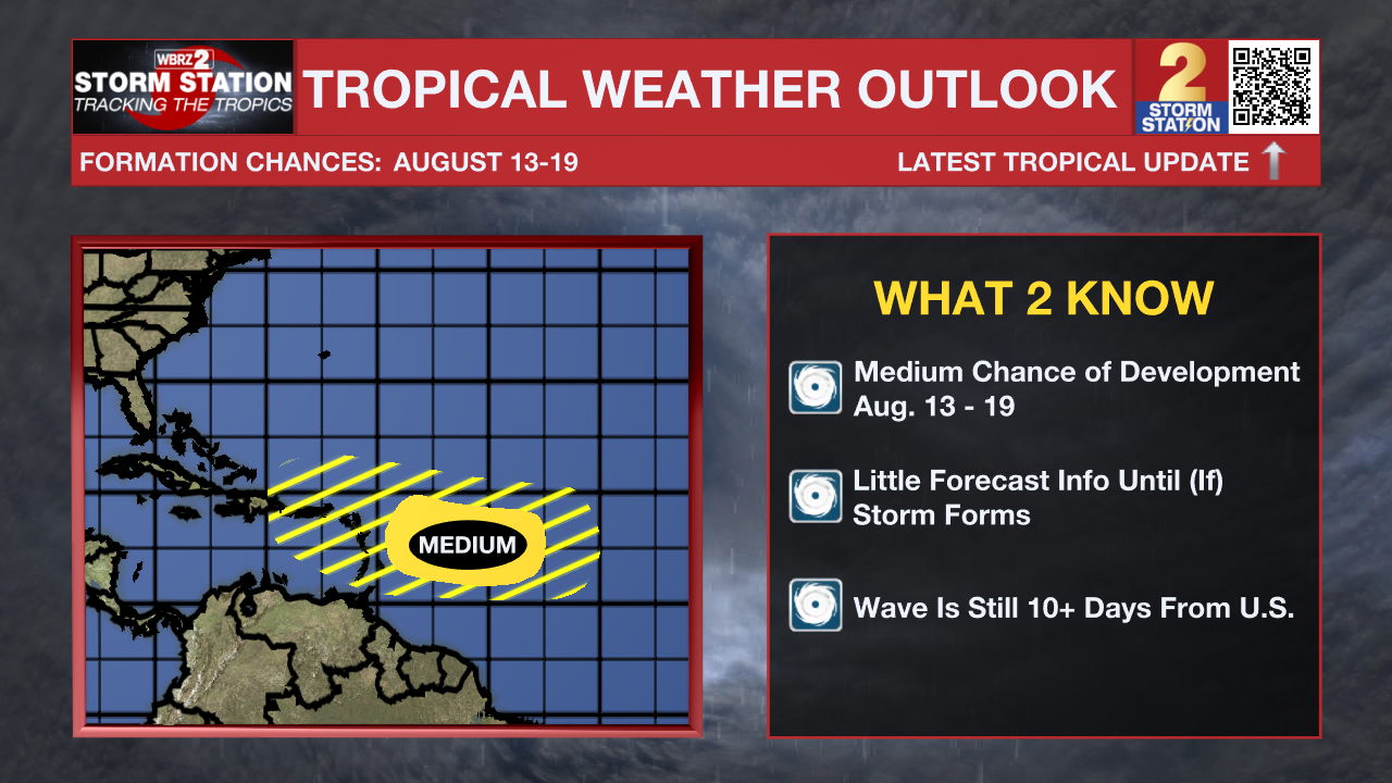
The Tropics: Tropical activity is starting to heat up in the Atlantic, and we're keeping an eye on a tropical wave that has just moved off the African Coast that will have a medium chance of development between August 13–19. As the graphic shows, the disturbance is still well out in the Atlantic and at least 10 days away from any potential U.S. impacts — if it develops at all. Forecast confidence remains low until a system actually forms, so now is a good time to stay aware, but there’s no immediate concern for our area.
A weak area of low pressure located a couple of hundred miles off the coast of North Carolina is producing a few disorganized showers and thunderstorms. Development of this system, if any, is expected to be slow to occur over the next day or so while it moves northeastward at 10 to 15 mph. The low is likely to merge with a front over the weekend, ending its chances for tropical or subtropical development.
A tropical wave over the central tropical Atlantic is producing minimal shower activity. Development of this system appears unlikely during the next day or two due to surrounding dry air, but environmental conditions are forecast to become more conducive in a few days. A tropical depression could form during the early or middle part of next week while the system moves northwestward to northward across the central tropical and subtropical Atlantic.
Trending News
Get the latest 7-day forecast and real-time weather updates HERE.
Watch live news HERE.
-- Josh
The Storm Station is here for you, on every platform. Your weather updates can be found on News 2, wbrz.com, and the WBRZ WX App on your Apple or Android device. Follow WBRZ Weather on Facebook and X for even more weather updates while you are on the go.
More News
