

Latest Weather Blog
Sunday AM forecast: Heat stays, but storms may return this afternoon
We’re headed for another hot and humid August day, but unlike Saturday, there will be a better chance for thunderstorms this afternoon. A Heat Advisory is in effect, with heat index values expected to reach 108° to 113° across the Capital Region.

Today and Tonight: The question of the day is how quickly storms can develop once temperatures climb into the mid 90s. Some favorable upper-level conditions could provide enough lift to help storms break through the cap during the hottest part of the afternoon.

Use the slider to advance through the next 24 hours of Futurecast
Isolated thunderstorms are expected from mid to late afternoon into the early evening. Most storms will be hit-or-miss, but the combination of strong instability and plenty of moisture means a few could become strong to severe. The primary concerns will be damaging winds, frequent lightning, and brief heavy rainfall. The strongest storms will also provide some temporary relief from the heat, but it won't be a widespread cooldown. It also shouldn’t be a widespread severe event like we had Friday.
Trending News
Up Next: Monday looks like a rinse and repeat, with another round of isolated afternoon storms and a few strong storms possible. Feels-like temps will remain in the 108° to 113° range, so more heat alerts are expected.
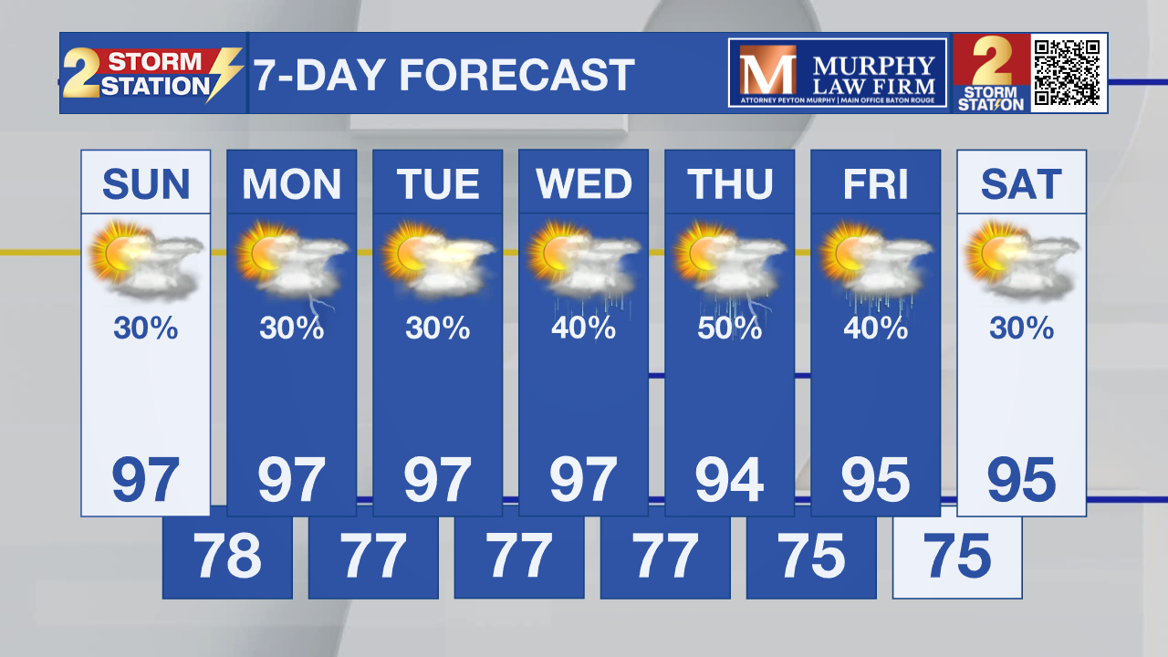
By Tuesday and Wednesday, the ridge begins to regain more control, which could scale back on storm coverage, but a few storms are still possible. The next more meaningful shift arrives Thursday and Friday, when an upper-level disturbance is expected to drift into the area. That could bring more numerous storms, more clouds, and temperatures dropping several degrees.

Tropics: There are no tropical threats to the Gulf in the near future. The National Hurricane Center is monitoring a broad area of low pressure southeast of Bermuda, with a 30% chance of development over the next seven days. Farther east, a tropical wave is expected to move off of the African coast Monday. Conditions could become more favorable for that system to develop later in the week, with a 50% chance of formation over the next seven days.
Get the latest 7-day forecast and real-time weather updates HERE.
Watch live news HERE.
– Dave
The Storm Station is here for you, on every platform. Your weather updates can be found on News 2, wbrz.com, and the WBRZ WX App on your Apple or Android device. Follow WBRZ Weather on Facebook and X for even more weather updates while you are on the go.
More News

