Sunday PM Forecast: Scattered afternoon storms Monday, Erin growing in size
Expect heat, humidity, and a good dosage of afternoon storms early in the week. Erin remains a powerful hurricane, and is starting to grow larger in size.
Tonight & Tomorrow: Overnight, expect mostly clear skies with lows near 76 degrees. Summer heat, humidity, and afternoon storms are not going anywhere! Highs will reach into the mid-90s by Monday afternoon. High humidity will make that feel into the triple digits at times. The combination of a favorable upper-level pattern, and decently high available moisture will lead to scattered PM storms. This means you got about a 50/50 shot at picking up measurable rainfall.
Up Next: Coverage ticks down a bit Tuesday and Wednesday as a tad drier air moves in. Highs will stay near the mid-90s. A weak front will approach the Capital Area by the end of the week. The lift from the front, along with increasing moisture will lead to enhanced storm coverage. Scattered to numerous storms are expected. Now don't freak out after hearing the word "front". This one is very weak, so expect very little to no temperature and humidity changes.

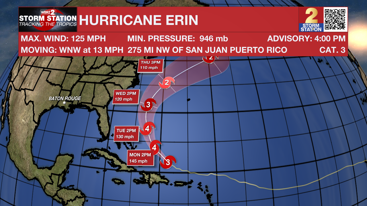
Hurricane Erin: Erin remains a powerful and well-organized hurricane, with plenty of thunderstorms and lightning around its center. Winds are estimated near 125 mph, and another Hurricane Hunter plane will check its strength later today. The storm is moving northwest at about 13 mph and is still on track to turn north in a couple of days. Conditions are favorable for it to stay a dangerous major hurricane through mid-week. The storm is also getting larger, which means rough seas and strong winds will extend farther from the center than usual across the western Atlantic. No direct landfall on the East Coast or Bermuda is expected at this time.
Trending News
Northwestern Atlantic: Recent satellite-derived winds indicate an elongated area of low pressure located a couple hundred miles off the coast of North Carolina with associated surface winds of less than 20 mph. Shower
activity remains limited, and development, if any, of this system should be slow to occur during the next day or so, while it drifts generally eastward. The opportunity for development should end on Monday, when environmental upper-level winds are expected to become unfavorable.
Central Tropical Atlantic: A tropical wave located near the Cabo Verde Islands is producing disorganized showers and thunderstorms. Some gradual development of this system is possible during the middle to latter portion of the week while the system moves westward to west-northwestward at 15 to 20 mph across the eastern and central tropical Atlantic.
Get the latest 7-day forecast and real-time weather updates HERE.
Watch live news HERE.
– Balin
The Storm Station is here for you, on every platform. Your weather updates can be found on News 2, wbrz.com, and the WBRZ WX App on your Apple or Android device. Follow WBRZ Weather on Facebook and X for even more weather updates while you are on the go.


