

Latest Weather Blog
Thursday PM Forecast: hot afternoons continue, wetter pattern around the corner
The weather pattern for Baton Rouge will be steady through the weekend before some changes arrive early next week. After a run of hot and mostly dry days, a wetter pattern will take shape.
Tonight & Tomorrow: After a dry day, expect similar conditions to carry through the night with clear skies. Lows will stop in the upper 60s. Friday will be mostly sunny. A slight increase in moisture plus a weak disturbance in the atmosphere could help to stir up a passing shower late. Highs will make it into the low 90s.
Friday Night Blitz: A stray shower is possible during the evening. While no games will be washed out, one or two fields could briefly get wet. Temperatures will start in the upper 80s for kickoff, but quickly cool into the upper 70s by the second half of the games.
LSU Football: If you are heading to LSU on Saturday for tailgating or the game, expect a mostly sunny and hot day with highs in the low 90s. Much like last weekend, sunscreen, hydration, and breaks in the shade will be key for tailgaters. Rain coverage of only about 10% is expected, so it’s unlikely that showers will interfere, but not impossible for a brief one in passing. It will stay sticky through kickoff into the evening with temperatures dropping out of the 90s into the low 80s.
Up Next: For the weekend as a whole, the pattern will not change much. Saturday and Sunday both bring a non-zero chance for showers, but most outdoor plans and weekend events should stay dry. Highs will hover in the low 90s, with mornings in the upper 60s and low 70s.
On Monday, astronomical fall officially begins, and so does a slightly more unsettled weather pattern. A series of upper-level disturbances will help to activate showers and thunderstorms Monday through Wednesday, at least. Rain coverage on any given day will be between 30-50% with most locations measuring rain at least once over that stretch. Thanks to the showers, highs may be closer to seasonal averages in the upper 80s.
Trending News
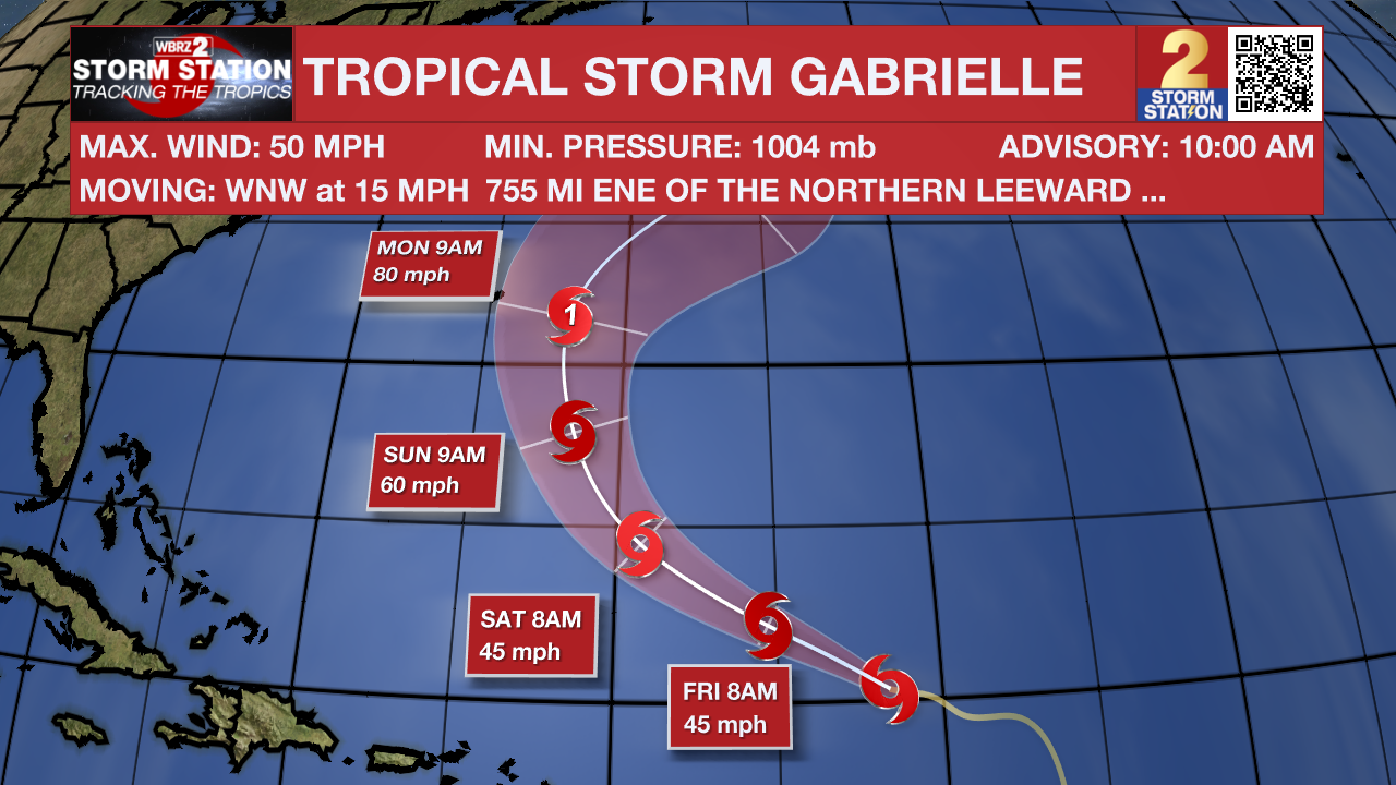
The Tropics: Tropical Storm Gabrielle is located in the central Atlantic, about 755 miles east-northeast of the northern Leeward Islands. Winds are holding near 50 mph, and the storm is moving west-northwest at 15 mph. Gabrielle is expected to maintain its strength for the next couple of days before gradually intensifying over the weekend as it curves more toward the northwest. Bermuda will need to monitor the progress of this system, but it does not pose a threat to the United States.
Get the latest 7-day forecast and real-time weather updates HERE.
Watch live news HERE.
– Josh
The Storm Station is here for you, on every platform. Your weather updates can be found on News 2, wbrz.com, and the WBRZ WX App on your Apple or Android device. Follow WBRZ Weather on Facebook and X for even more weather updates while you are on the go.
More News
