

Latest Weather Blog
Tuesday PM Forecast: pop-up showers remain possible, eye on outdoor plans this weekend
Only subtle day-to-day variations are expected in showers and thunderstorms through the end of the week. Increasing tropical moisture needs to be monitored for potential forecast changes into next week.
Tonight & Tomorrow: Evening showers and thunderstorms will rapidly diminish due to the loss of daytime heating. Expect partly cloudy skies and lows in the mid-70s. On Wednesday, expect a mix of sun and clouds with an isolated 30% coverage in pop-up showers and thunderstorms. With partly sunny skies outside of showers, highs will be in the low 90s.
Up Next: As we move into Thursday and Friday, the rain coverage will dip slightly to spotty 20% action. We'll see plenty of sunshine, and temperatures will remain consistently warm, hovering in the low 90s during the day and in the mid-70s at night.
The forecast challenge comes this weekend. A surge of tropical moisture from the eastern Gulf will approach. While it is not expected to be associated with anything significantly developed, how close it gets to our coastline will determine chances for showers and thunderstorms into early next week. As of now, a drier, near-average forecast of spotty showers and thunderstorms is favored for inland sections with slightly more action near the coast. Should the slug of moisture and associated disturbance get a little closer, afternoon activities could have a tougher time dodging rain by late weekend or early next week. As far as temperatures go, highs will stay in the low 90s with lows in the mid-70s.
Trending News
The Tropics: Tropical Storm Dexter has gotten a bit weaker on Tuesday with winds of 40mph, about 400 miles north of Bermuda. It's moving northeast and is expected to get a little stronger in the next couple of days, even as it transitions into a post-tropical storm. There are no coastal watches or warnings in effect, and it poses no immediate hazards to land.
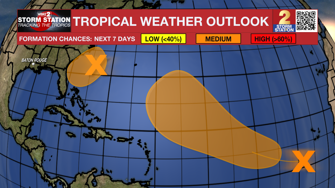
A weak surface trough located several hundred miles off the coast of the southeastern United States has been producing scattered showers and thunderstorms Tuesday. An area of low pressure is expected to develop from this system over the next day or so, where environmental conditions appear generally favorable for additional development. A tropical depression could form by the latter portion of this week or weekend as the low starts moving slowly westward, but turns more northward by this weekend.
A tropical wave over the far eastern tropical Atlantic has been producing a disorganized area of showers and thunderstorms. Environmental conditions are forecast to be conducive for gradual development during the next few days, and a tropical depression could form late this week or over the weekend as the system moves generally west-northwestward across the central tropical or subtropical Atlantic.
Get the latest 7-day forecast and real-time weather updates HERE.
Watch live news HERE.
– Josh
The Storm Station is here for you, on every platform. Your weather updates can be found on News 2, wbrz.com, and the WBRZ WX App on your Apple or Android device. Follow WBRZ Weather on Facebook and X for even more weather updates while you are on the go.
More News
