

Latest Weather Blog
Wednesday PM Forecast: Heat taking the spotlight, prompting new alerts
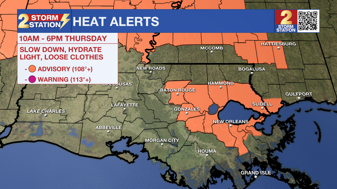
Heat will be a primary fixture moving into the weekend as drier conditions take over. A Heat Advisory has been issued for Thursday, with more likely in the days to follow. Meanwhile, Tropical Storm Erin is just days away from becoming a hurricane.
Tonight & Tomorrow: An ordinary night is ahead. Lingering showers will wrap up, skies will clear out, and overnight lows will settle in the mid-70s. Temperatures will soar into the mid-90s by Thursday afternoon, with humidity making it feel even warmer. As some neighborhoods might experience a feels-like temperature over 108°, a Heat Advisory has been issued for Baton Rouge and points southeast. Especially if outside for an extended period, stay hydrated and take breaks to avoid overheating. Pockets of tropical moisture may support a round of isolated showers and thunderstorms. However, not all will experience them. About a third will receive rain due to their hit-or-miss nature, with coastal areas favored to see it.
Up Next: Rain coverage will continue to taper into Thursday and Friday. With fewer storms around, temperatures will climb higher. Look for highs in the mid-90s on Friday through Sunday. Taking humidity into account, heat index readings could reach the 106-110° range. That’s high enough additional heat alerts to be on the table. There will be a minor ripple in the upper atmosphere moving in on Sunday, which could bring a slight uptick in afternoon storms. But nevertheless, it will still be plenty hot. Next week will bring no major change to the forecast with continued hot and muggy conditions with a few pop-up afternoon storms.
The Tropics: Erin maintained its intensity as a tropical storm through Wednesday morning. The storms will soon intensify, likely becoming the first hurricane of the season by late week and possibly the first major hurricane over the weekend. While no watches or warnings have been posted yet, residents of the northern Leeward Islands, the Virgin Islands, Puerto Rico, and the Bahamas should monitor its progress. Long-range guidance suggests a recurve north into the Atlantic Ocean, but it remains unclear exactly when and where that will happen. In any event, a track into the Gulf is not expected.

A tropical wave composed of disorganized thunderstorms located over the Yucatan Peninsula will move into the southwest Gulf on Thursday. Some organization of this system is possible as it moves over the warm water. The window for tropical formation will be short, and development odds are low at this time. Regardless, the system will move inland over northeastern Mexico by late Friday with no threat to the northern Gulf Coast.
Trending News
Get the latest 7-day forecast and real-time weather updates HERE.
Watch live news HERE.
— Meteorologist Malcolm Byron
The Storm Station is here for you, on every platform. Your weather updates can be found on News 2, wbrz.com, and the WBRZ WX App on your Apple or Android device. Follow WBRZ Weather on Facebook and X for even more weather updates while you are on the go.
More News
